Geologic Units |
|
| Quaternary alluvial deposits | |
| Quaternary surficial cover, fluveolian cover on Snake River Plain, alluvial fans (Snake River Group) | |
| Quaternary landslide deposits (only Weiser area) | |
| Tertiary sedimentary rocks, undifferentiated | |
| Miocene basalt (Columbia River Basalt Group) | |
| Miocene basalt (basalt of Weiser and basalt of Cuddy Mtn.) (split with Tpb is at 5 Ma) (includes rocks shown as Tpb (Bond, 1978) in Owyhee County and Mt. Bennett Hills | |
| Cretaceous syenitic rocks | |
| Cretaceous tonalite and quartz diorite | |
| Cretaceous orthogneiss, and foliated granodiorite and granite (includes mylonitic plutonic rocks in western Idaho suture zone) | |
| Riggins Group and Orofino series | |
| Island-arc volcanic and intrusive complex | |
| Dioritic, gabbroic, granitic, and amphibolitic rocks of the Blue Mountains island arc terrane | |
| Felsic plutonic rocks intruded into the accreted terranes of western Idaho (includes tonalite and trondhjemite and granodiorite) | |
| Seven Devils Group (Wallowa Terrane) | |
| Olds Ferry Terrane | |
| Intrusive rocks of the Wallowa Terrane | |
| Martin Bridge and Hurwal Formations (Wallowa Terrane) | |
| Baker Terrane |
| Map Key | |
| Geologic units with unit designation. | |
| Normal Fault: certain; dashed where approximately located; dotted where concealed. | |
| Thrust Fault: certain; dashed where approximately located; dotted where concealed. | |
| Detachment Fault: certain; dashed where approximately located; dotted where concealed. | |
| Interstate Route. | |
| U.S. Route. | |
| State Route. | |
| Location of Rockwalk rock from the county. | |
| Cities. | |
| Feature location. |
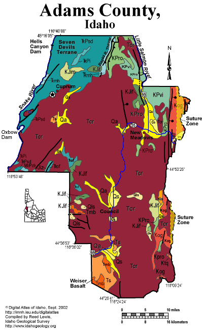
Adams County
Adams County lies mainly west of the Idaho Suture zone, and is underlain by accreted terrane rocks covered by Miocene Columbia River basalt flows. The suture zone runs east of New Meadows. East of the suture are Cretaceous tonalites of the Idaho batholith. West of the suture are diverse Paleozoic and Mesozoic metavolcanic and metasedimentary rocks that were accreted to North America in the Early Cretaceous. The Rapid River thrust is one of the bounding faults between these subducted terranes. .
The Snake River in Hells Canyon forms the western boundary of the state and Adams County.
The geology of the region between Riggins and Boise to the south reflects a long history of plate boundary interactions and terrestrial responses. Exposed along this route is the eastern edge of the Miocene Columbia River Basalt and associated sedimentary units, the western edge of the extensive plutonic rocks that comprise the late Cretaceous Idaho Batholith, and metamorphosed sedimentary and volcanic rocks of the Jurassic Seven Devils group.
During the Jurassic, an oceanic trench formed off the western margin of North American near the present western Idaho border. North America was moving west, away from the mid-Atlantic oceanic ridge. As the North American continental plate moved westward, the Pacific oceanic plate slid beneath it, and thus beneath the location of the future Idaho. Riding on top of the Pacific oceanic floor were numerous island arcs that eventually were emplaced onto the western margin of North America - prime examples of these emplaced volcanoes are the Seven Devils along Hells Canyon.
These rocks are visible in Hells Canyon, along US Hwy 95 outside of Riggins, and along State Hwy 55 and US Hwy 95 near New Meadows.
For more information on plate boundaries and plate motions, please visit the USGS website http://geology.er.usgs.gov/eastern/tectonic.html.
Miocene lacustrine and fluvial rocks are found in the southwest corner of the county south of Council. The largest area of outcrop in the county is underlain by Miocene Columbia River basalt flows. These are visible along US Hwy 95. They were erupted from fissure eruptions. The Columbia River basalt flows dammed streams and sedimentary units were deposited in the heads of valleys as the result of stream blockage. For more information on the Columbia River Basalts visit the University of North Dakota Volcano World website http://volcano.und.nodak.edu/vwdocs/volc_images/north_america/crb.html.
Excellent discussion of the geology of this area is found in Orr, W.N., and Orr, E.L., 2002, Geology of the Pacific Northwest, 2nd ed., McGraw Hill Pubs., p. 138-159.
Good information is also contained in Alt, D. D., and Hyndman, D.W., 1989, Roadside Geology of Idaho, Mountain Press, Missoula, 393 p.
Tamra Schiappa and P.K. Link, 10/02
Additional Reading
Rocks Rails and Trails: pages
Challis Volcanic Group & Intrusive Rocks &
References on Idaho Geology
Click here to see a correlation of geologic units, and the associated time scale.
Click here for a printable version of this map.
Click here for a discussion of the geology of Adams, Washington and Southern Idaho Counties (PDF)
|
Click on the button below to search the IdahoGeologic
Survey's index of Geologic Maps
|
 |