 |
|
Click on the map above for a larger version
|
Geologic Units |
|
| Quaternary alluvial deposits | |
| Quaternary surficial cover, fluveolian cover on Snake River Plain, alluvial fans (Snake River Group) | |
| Pleistocene silicic volcanic rocks (Yellowstone Group) | |
| Quaternary landslide deposits (only Weiser area) | |
| Tertiary sedimentary rocks, undifferentiated | |
| Miocene basalt (Columbia River Basalt Group) | |
| Eocene granodiorite, granite, diorite, and shallow dacitic intrusive | |
| Eocene granite, pink granite, syenite, rhyolite dikes, and rhyolitic shallow intrusive | |
| Cretaceous granite and granodiorite of the 2-mica suite (Idaho batholith) | |
| Paleozoic/Mesoproterozoic schist and quartzite | |
| Cretaceous tonalite and quartz diorite |
| Map Key | |
| Geologic units with unit designation. | |
| Normal Fault: certain; dashed where approximately located; dotted where concealed. | |
| Thrust Fault: certain; dashed where approximately located; dotted where concealed. | |
| Detachment Fault: certain; dashed where approximately located; dotted where concealed. | |
| Interstate Route. | |
| U.S. Route. | |
| State Route. | |
| Location of Rockwalk rock from the county. | |
| Cities. | |
| Feature location. |
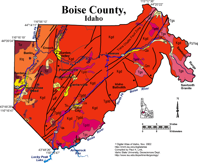
Boise County
Boise County contains a huge area of the central Idaho Mountains between Ada County and the city of Boise and the Sawtooth Mountains on the east. This country is drained by the Payette and Boise Rivers, Grimes Creek and Bear Valley Creek. Most of the area is underlain by Cretaceous granodiorite of the Idaho batholith. Eocene intrusions are present in the Sawtooth Mountains on the east and in the Idaho City area. Near Idaho City are extensive placer gold workings from the 19th century. Mineralization was along a northeast trending fault zone associated with the Trans Challis fault zone (Great Falls lineament). A north-tending Basin and Range fault, down on the east bounds the system of northeast-striking trans-Challis faults.
In the western part of the county, west of Horseshoe Bend on the Payette River is tonalitic intrusive rock of the Idaho batholith, and Miocene Columbia River basalt in the valleys. This basalt flowed north east, or up the valleys from sources to the west in Oregon and westernmost Idaho.
Horseshoe Bend is the site of recurrent landslides in Miocene sedimentary rocks of the Payette Formation. These landslides caused rerouting of highway 55 to avoid the active scarps.
P.K. Link, 10/02
Additional Reading
Rocks Rails and Trails: page
References on Idaho Geology
Click here to see a correlation of geologic units, and the associated time scale.
Click here for a printable version of this map.
|
Click on the button below to search the IdahoGeologic
Survey's index of Geologic Maps
|
 |