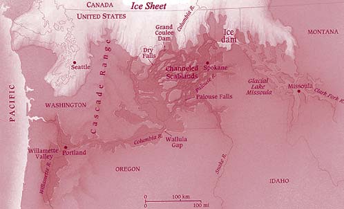
Glacial Lake Missoula was
formed, numerous times, during the last major ice age between 15,500 and 13,500
years ago. A lobe of a glacier flowed down the Purcell trench in northern Idaho
damming the Clark Fork River at the present site of Pend Oreille Lake, creating
Glacial Lake Missoula. Lake Missoula stretched for hundreds of miles across
western Montana and contained more water than Lake Erie and Lake Ontario combined.
It's estimated that at its maximum the elevation of the lake rose to 4,350 feet,
with water as deep as 2000 feet at the ice dam. The breaching of this ice dam
numerous times (anywhere from 41 to 89 separate events), released the largest
floods known to have occurred for which evidence is found.
Just as ice floats in your
glass of water, the ice dam holding this large volume of water is eventually
going to float. When these ice dams broke it's been estimated that a wall of
water 2000 feet high and racing at 45 miles per hour rushed across the landscape,
scouring everything in its path. The amount of water released would have been
approximately 450 times the maximum flow ever recorded on the Mississippi River.
The scablands were created in Idaho and eastern Washington as these large floods
quickly stripped away 200 feet of soil and cut deep canyons into the underlying
bedrock. In the wake of these floods depositional features such as 50 foot high
ripple marks, gravel bars as tall as 30 story buildings, and boulders weighing
more than 200 tons were left scattered across the landscape.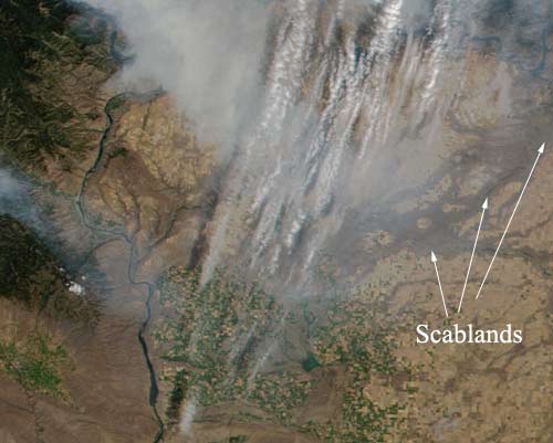
In narrow canyons rivers were forced to reverse their flows as these tremendous amounts of water rushed to the sea. The Snake River reversed and sediments from the floods are left all the way past Lewiston, Idaho.
For more information concerning the Missoula Floods visit the following sites:
http://www.pbs.org/wgbh/nova/megaflood/