Geologic Units |
|
| Quaternary alluvial deposits | |
| Quaternary surficial cover, fluveolian cover on Snake River Plain, alluvial fans (Snake River Group) | |
| Recent basalt lava | |
| Pleistocene basalt lava | |
| Miocene felsic volcanic rocks (Idavada volcanics), includes rocks designated as Tmf (Bond, 1968) in Owyhee County and Mt. Bennett Hills | |
| Miocene basalt (basalt of Weiser and basalt of Cuddy Mtn.) (split with Tpb is at 5 Ma) (includes rocks shown as Tpb (Bond, 1978) in Owyhee County and Mt. Bennett Hills | |
| Eocene Challis Volcanic Group, volcanics and volcaniclastics | |
| Eocene granite, pink granite, syenite, rhyolite dikes, and rhyolitic shallow intrusive | |
| Eocene granodiorite, granite, diorite, and shallow dacitic intrusive | |
| Cretaceous granite and granodiorite of the 2-mica suite (Idaho batholith) | |
| Cretaceous tonalite and quartz diorite | |
| Permian and Pennsylvanian sedimentary rocks | |
| Paleozoic/Mesoproterozoic schist and quartzite |
| Map Key | |
| Geologic units with unit designation. | |
| Normal Fault: certain; dashed where approximately located; dotted where concealed. | |
| Thrust Fault: certain; dashed where approximately located; dotted where concealed. | |
| Detachment Fault: certain; dashed where approximately located; dotted where concealed. | |
| Interstate Route. | |
| U.S. Route. | |
| State Route. | |
| Location of Rockwalk rock from the county. | |
| Cities. | |
| Feature location. |
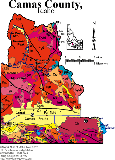
Camas County
Camas County contains the Soldier Mountains, Camas Prairie and Mout Bennett Hills on the northern edge of the Snake River Plain, west of the Wood River.
The Camas Prairie is a flat, alluvial covered agricultural area, downdropped from the Soldier Mountains by a concealed normal fault. The Mount Bennett Hills contain Miocene (12 to 8 Ma) rhyolites from the Twin Falls volcanic centers. The latest Miocene Magic Reservoir rhyolite dome and eruptive complex is found in the southeast corner of the county.
The Soldier Mountains, and the Smoky Mountains to the northeast are underlain by Cretaceous granodiorite from the Idaho batholith, as well as complex Eocene intrusive complexes associated with the Challis magmatic episode. Diverse metallic mineral deposits occur here, associated with carbonaceous Paleozoic rocks of the central Idaho black-shale mineral belt, and Cretaceous and Eocene hydrothermal mineralizing systems.
See sections on geology of this area in Rocks, Rails and Trails.
P.K. Link, 10/02
Additional Reading
Rocks Rails and Trails:
The Snake River Plain-Yellowstone Hot Spot and its Effect on Drainage Patterns
Drainage Systems, Rails and Trails
Geologic Provinces along the Oregon Trail
Rocks of the Eastern Idaho Mountains
Rocks of Central Idaho
Pictures -Idaho Mountains
Challis Volcanic Group & Intrusive Rocks
References on Idaho Geology
Section 8, Chapter 24 -Ketchum, Sun Valley, and Shoshone
Click here to see a correlation of geologic units, and the associated time scale.
Click here for a printable version of this map.
|
Click on the button below to search the IdahoGeologic
Survey's index of Geologic Maps
|
 |