|
|
Click on the map above for a larger version
|
Geologic Units |
|
| Quaternary surficial cover, fluveolian cover on Snake River Plain, alluvial fans (Snake River Group) | |
| Quaternary windblown deposits, dunes, loess | |
| Pleistocene basalt lava | |
| Pleistocene silicic volcanic rocks (Yellowstone Group) | |
| Eocene Challis Volcanic Group, volcanics and volcaniclastics | |
| Triassic sedimentary rocks | |
| Permian and Carboniferous sedimentary rocks (Snaky Canyon Formation) | |
| Mississippian sedimentary rocks | |
| Mississippian and Devonian sedimentary rocks | |
| Paleoproterozoic gneiss |
| Map Key | |
| Geologic units with unit designation. | |
| Normal Fault: certain; dashed where approximately located; dotted where concealed. | |
| Thrust Fault: certain; dashed where approximately located; dotted where concealed. | |
| Detachment Fault: certain; dashed where approximately located; dotted where concealed. | |
| Interstate Route. | |
| U.S. Route. | |
| State Route. | |
| Location of Rockwalk rock from the county. | |
| Cities. | |
| Feature location. |
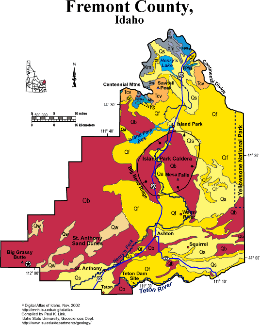
Fremont County
Fremont County occupies the northeast corner of the Snake River Plain and includes the western fringe of Yellowstone National Park. It is mainly underlain by volcanic rocks associated with the Snake River Plain and Yellowstone hot spot system. Quaternary sediments overlies these volcanic rocks and allow irrigated farming. The windblown St. Anthony sand dunes contain sand blown northeastward from now-dry lakes to the southwest on the Snake River Plain.
The Island Park area forms the central part of Fremont County, and consists of the subsided Island Park Caldera, that erupted about 1.2 million years ago to form the Mesa Falls tuff, and then subsided since its underpinnings were withdrawn. As one drives north on the Ashton grade, one ascends the wall of the caldera.
The Centennial Mountains, on the north edge of Fremont County, on the border with Montana, form the Continental divide. These mountains contain Paleoproterozoic gneiss basement, overlain by Cambrian through Triassic sedimentary rocks. These Paleozoic rocks are similar to those of the Teton Mountains, and much thinner than those of the Beaverhead Range to the west.
On the southeast edge of Fremont County, south of Ashton, flows the Teton River, cut in a steep canyon through 2 million year old Huckleberry Ridge rhyolite welded tuff. It was here, in 1975, that the newly build Teton Dam broke, causing death and destruction downstream toward Newdale, Teton and Rexburg.
P.K. Link, 9/02
Additional Reading
Rocks Rails and Trails: pages
The Snake River Plain-Yellowstone Hot Spot and its Effect on Drainage Patterns
Challis Volcanic Group & Intrusive Rocks
References on Idaho Geology
Click here to see a correlation of geologic units, and the associated time scale.
Click here for a printable version of this map.
|
Click on the button below to search the IdahoGeologic
Survey's index of Geologic Maps
|
 |