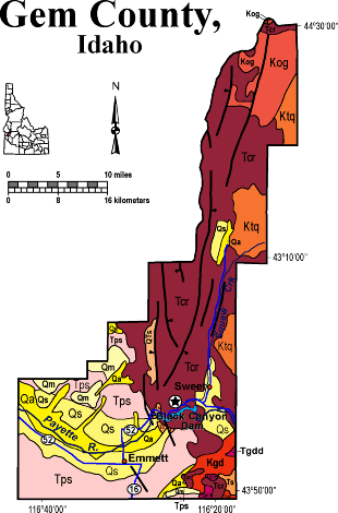
Geologic Units |
|
| Quaternary alluvial deposits | |
| Quaternary moraine and glaciofluvial outwash | |
| Quaternary surficial cover, fluveolian cover on Snake River Plain, alluvial fans (Snake River Group) | |
| Pleistocene and Pliocene stream and lake deposits | |
| Pliocene and Upper Miocene stream and lake deposits (Salt Lake Formation, Starlight Formation, Idaho Group) | |
| Tertiary sedimentary rocks, undifferentiated | |
| Miocene basalt (Columbia River Basalt Group) | |
| Eocene granodiorite, granite, diorite, and shallow dacitic intrusive | |
| Cretaceous granite and granodiorite of the 2-mica suite (Idaho batholith) | |
| Cretaceous orthogneiss, and foliated granodiorite and granite (includes mylonitic plutonic rocks in western Idaho suture zone) | |
| Cretaceous tonalite and quartz diorite |
| Map Key | |
| Geologic units with unit designation. | |
| Normal Fault: certain; dashed where approximately located; dotted where concealed. | |
| Thrust Fault: certain; dashed where approximately located; dotted where concealed. | |
| Detachment Fault: certain; dashed where approximately located; dotted where concealed. | |
| Interstate Route. | |
| U.S. Route. | |
| State Route. | |
| Location of Rockwalk rock from the county. | |
| Cities. | |
| Feature location. |
Gem County
Gem County covers a small area on the northern border of the Snake River Plain, including the drainage of Squaw Creek and the main channel of the Payette Rvier.
On the southwest are outcrops of Miocene to Recent lake and fluvial beds in bluffs above the Payette River. Much of the northern panhandle of the county is underlain by Miocene (17 Ma) Columbia River basalt. North-trending fault zones parallel Squaw Creek and control the linear topography of the northern county.
On the eastern edge of the county are several outcrops of Cretaceous tonalite, orthogneiss and granodiorite of the Idaho batholith complex.
Cenozoic Geologic History of Gem and Payette Counties
The Cenozoic geologic history of Gem and Payette Counties is similar to many areas in southwestern Idaho. Volcanism resulted mainly from the faulting and initiation of the Western Snake River Plain in the Miocene. Miocene sedimentation occurred within the many lakes interconnected at times by a river system that was present in the newly formed rift environment. Columbia River volcanic flows and pyroclastic rocks that were erupted from both central and fissure-type vents represent the oldest volcanic rocks in the area. These lava flows temporarily blocked major surface water drainages causing extensive deposits of alluvial, fluvial and lacustrine sediments referred to as the Miocene - Pliocene Payette and Sucker Creek and Pliocene - Pleistocene Idaho Formations. The age of these sedimentary deposits ranges from Miocene to the Pleistocen. These units exhibit many sedimentary structures. The fluvial facies exhibits cross bedding, ripples, scouring, and delta foresets. Well-preserved fluvial and lacustrine facies of the Idaho Formation can be observed along Old Freeze Out Hill Road.
Columbia River basalts are widely distributed over Gem County and parts of eastern Payette County. Squaw Mountain represents a major block of the Columbia River Basalt which is estimated to have been uplifted approximately 2500' along its eastern margin (Savage, 1961). Other exposures of Columbia River basalts can be observed along the north side of Black Canyon Reservoir. Silicic volcanic rocks, rhyolitic welded ash flow tuffs, also crop out in the region and are stratigraphically above the Columbia River basalt units. Exposures of the rhyolitic ash flow tuff units can be observed in the Pearl region.
T. Schiappa and P.K. Link, 10/02
Additional Reading
Rocks Rails and Trails: page
References on Idaho Geology
Click here to see a correlation of geologic units, and the associated time scale.
Click here for a printable version of this map.
Click here for a discussion of the geology of Payette and Gem Counties (PDF)
|
Click on the button below to search the IdahoGeologic
Survey's index of Geologic Maps
|
 |