Geologic Units |
|
| Quaternary alluvial deposits | |
| Gravels and terraces on western Snake River Plain | |
| Pleistocene basalt lava | |
| Recent basalt lava, less than 12,000 years old, lava flows are fresh, poorly vegetated, and show original flow geometry. | |
| Pleistocene and Pliocene gravels on western Snake River Plain | |
| Eocene Challis Volcanic Group, volcanics and volcaniclastics | |
| Pliocene and Upper Miocene basalt (Starlight Formation, Salt Lake Formation) | |
| Pliocene and Upper Miocene felsic volcanic rocks, rhyolite flows, tuffs, ignimbrites (includes Moonstone rhyolite) |
| Map Key | |
| Geologic units with unit designation. | |
| Normal Fault: certain; dashed where approximately located; dotted where concealed. | |
| Thrust Fault: certain; dashed where approximately located; dotted where concealed. | |
| Detachment Fault: certain; dashed where approximately located; dotted where concealed. | |
| Interstate Route. | |
| U.S. Route. | |
| State Route. | |
| Location of Rockwalk rock from the county. | |
| Cities. | |
| Feature location. |
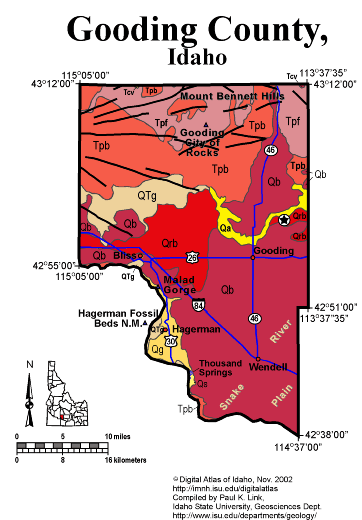
Gooding County
Gooding County is entirely on the Snake River Plain, north of the Snake River. Thus all the rocks are Miocene and younger, with Quaternary basalt covering most of the county.
In the north the Gooding City of Rocks, carved from Miocene rhyolite ignimbrites of the Twin Falls Volcanic Field, forms the south flank of the Mount Bennett Hills. A series of east-west normal faults cuts the Mount Bennett Hills, reflecting the rift-valley structure of the western Snake River Plain.
On the south, in the Snake River Canyon, are exposures of Miocene and Pliocene Glenns Ferry Formation below the Quaternary basalt flows. Hagerman Fossil Beds National Monument, itself located on the west side of the Snake River in Twin Falls County, has its headquarters in Hagerman.
Malad Gorge, a narrow canyon cut by the Wood River in the last few hundred thousand years, is a unique feature of southern Gooding County.
P.K. Link, 9/02
Additional Reading
Rocks Rails and Trails: pages
Challis Volcanic Group & Intrusive Rocks
Lake Bonneville and its Flood
Disposal of Wastes at the Idaho National Engineering & Environmental Laboratory
References on Idaho Geology
Section 7, Chapter 23 - Twin Falls Area & the Magic Valley
Hagerman Valley
Click here to see a correlation of geologic units, and the associated time scale.
Click here for a printable version of this map.
|
Click on the button below to search the IdahoGeologic
Survey's index of Geologic Maps
|
 |