Geologic Units |
|
| Quaternary alluvial deposits | |
| Recent basalt lava | |
| Pleistocene basalt lava | |
| Pleistocene and Pliocene basalt lava and associated tuff | |
| Pliocene and Upper Miocene felsic volcanic rocks, rhyolite flows, tuffs, ignimbrites (includes Moonstone rhyolite) | |
| Pliocene and Upper Miocene basalt (Starlight Formation, Salt Lake Formation) |
| Map Key | |
| Geologic units with unit designation. | |
| Normal Fault: certain; dashed where approximately located; dotted where concealed. | |
| Thrust Fault: certain; dashed where approximately located; dotted where concealed. | |
| Detachment Fault: certain; dashed where approximately located; dotted where concealed. | |
| Interstate Route. | |
| U.S. Route. | |
| State Route. | |
| Location of Rockwalk rock from the county. | |
| Cities. | |
| Feature location. |
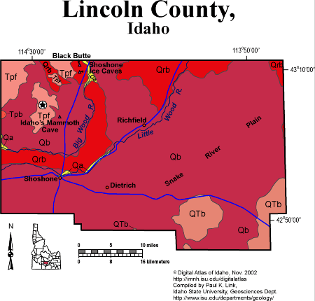
Lincoln County
Lincoln County, close to the geographic center of the Snake River Plain, is entirely underlain by volcanic rock less then 10 million years old. The bulk of the county is Quaternary basalt lava, erupted from several shield volcanoes and fissure systems that are still visible. Farming near Richfield and Shoshone is possible in areas where alluvial or windblown soil has accumulated, and requires irrigation from the Big and Little Wood Rivers.
The main line of the Union Pacific Railroad crosses the basalt lava east-west through Shoshone, which started as a railroad town. The Ketchum and Camas Prairie branches of the Union Pacific run northeast through Richfield, following the Little Wood River.
Black Butte basalt volcano in the northwest part of the county, erupted in the last 10,000 years, producing a river of lava that flowed down the Big Wood River canyon. Shoshone ice caves are found in a lava tube, or underground pipe, where the molten lava flowed.
Late Miocene rhyolites of the Magic Reservoir volcanic field (5 Ma) are found west of Black Butte.
See discussion of Snake River Plain-Yellowstone volcanism in Rocks, Rails and Trails, plus the Topographic Development of Idaho maps.
P.K. Link, 10/02
Additional Reading
Rocks Rails and Trails: pages
The Snake River Plain-Yellowstone Hot Spot and its Effect on Drainage Patterns
Challis Volcanic Group & Intrusive Rocks
Lake Bonneville and its Flood
Disposal of Wastes at the Idaho National Engineering & Environmental Laboratory
References on Idaho Geology
Section 3, History of Eastern Idaho
Section 3, Chapter 8 -"Famous Potatoes" Agriculture & Irrigation
Section 7, Chapter 23 - Twin Falls Area & the Magic Valley
Click here to see a correlation of geologic units, and the associated time scale.
Click here for a printable version of this map.
|
Click on the button below to search the IdahoGeologic
Survey's index of Geologic Maps
|
 |