Geologic Units |
|
| Miocene basalt (Columbia River Basalt Group) | |
| Cretaceous tonalite and quartz diorite | |
| Dioritic, gabbroic, granitic, and amphibolitic rocks of the Blue Mountains island arc terrane | |
| Coon Hollow Formation (Wallowa Terrane) | |
| Martin Bridge and Hurwal Formations (Wallowa Terrane) | |
| Seven Devils Group (Wallowa Terrane) |
| Map Key | |
| Geologic units with unit designation. | |
| Normal Fault: certain; dashed where approximately located; dotted where concealed. | |
| Thrust Fault: certain; dashed where approximately located; dotted where concealed. | |
| Detachment Fault: certain; dashed where approximately located; dotted where concealed. | |
| Interstate Route. | |
| U.S. Route. | |
| State Route. | |
| Location of Rockwalk rock from the county. | |
| Cities. | |
| Feature location. |
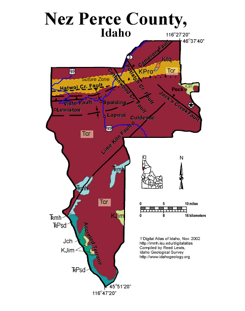
Nez Perce County
Almost all of Nez Perce County is underlain by the Miocene basalts of the Columbia River basalts which make up the steep sided plateau south of Lewiston. South of the suture zone, which runs east-west along the Clearwater River through Lewiston, these basalts lapped against Cretaceous and Jurassic island arc and sedimentary rocks of the Seven Devils complex and other accreted terranes.
The Miocene basalts filled in and flowed up an ancestral Clearwater River canyon about 17 million years ago.
Written by P.K. Link, 9/02
Additional Reading
Rocks Rails and Trails: page
References on Idaho Geology
Click here to see a correlation of geologic units, and the associated time scale.
Click here for a printable version of this map.
|
Click on the button below to search the IdahoGeologic
Survey's index of Geologic Maps
|
 |