 |
|
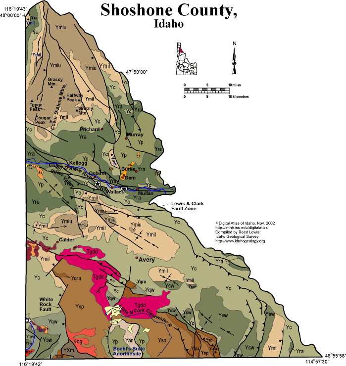
Click on the map for a larger version
|
Geologic Units |
|
| Quaternary alluvial deposits | |
| Quaternary moraine and glaciofluvial outwash | |
| Eocene granodiorite, granite, diorite, and shallow dacitic intrusive | |
| Tertiary sedimentary rocks, undifferentiated | |
| Miocene basalt (Columbia River Basalt Group) | |
| Cretaceous granite and granodiorite of the 2-mica suite (Idaho batholith) | |
| Cretaceous orthogneiss, and foliated granodiorite and granite (includes mylonitic plutonic rocks in western Idaho suture zone) | |
| Cretaceous syenitic rocks | |
| Lower Missoula Group. Lower part-- Gunsight Formation (Snowslip and Shepard) | |
| Upper Missoula Group. Upper part Swauger Quartzite (Mount Shields, Bonner, and Libby Fms.) | |
| Piegan Group or Middle Belt carbonate, Apple Creek Formation (includes Cobalt and Yellowjacket Formations, and Yaq argillaceous quartzite unit of Ekren) | |
| Quartzite and schist of the Ravalli group | |
| Mesoproterozoic anorthosite | |
| Schist of the Wallace Formation and lower Missoula Group | |
| Quartzite and calc-silicate gneiss of the Wallace Formation | |
| Quartzite and schist of the Prichard Formation | |
| Prichard Formation (Lower Belt), includes Yqcp quartzite and carbonate rocks in Prichard | |
| Ravalli Group, includes Hoodoo Quartzite, Big Creek Formation, Yellowjacket Formation, lower part of Lemhi Group | |
| Metamorphic rocks, Elk City metamorphic sequence and related rocks, Syringa metamorphic sequence, and Priest River metamorphic complex |
| Map Key | |
| Geologic units with unit designation. | |
| Normal Fault: certain; dashed where approximately located; dotted where concealed. | |
| Thrust Fault: certain; dashed where approximately located; dotted where concealed. | |
| Detachment Fault: certain; dashed where approximately located; dotted where concealed. | |
| Interstate Route. | |
| U.S. Route. | |
| State Route. | |
| Location of Rockwalk rock from the county. | |
| Cities. | |
| Feature location. |
Shoshone County
Shoshone County covers a huge area north of the Clearwater River, and including the Silver Valley, which was a main source of wealth in north Idaho for much of the 20th century. Much of Shoshone County is rugged, tree-covered mountains, with people only living and traveling along the east-west corridor along the South Fork Coeur d'Alene River through Kellogg and Wallace. The Silver Valley follows the Lewis and Clark shear zone, an intracontinental fault zone with multiple stages of movement that extends eastward through much of southwest Montana.
The silver and lead mineral deposits of the Silver Valley are hosted by the Revett Quartzite of the Belt Supergroup, and occupy huge veins in shear zones. Today the environmental cleanup of mine wastes in the area pumps millions of dollars into the economy deflated by closure of most of the mines.
Most of the rocks in Shoshone County are Mesoproterozoic Belt Supergroup, deformed into northeast-vergent folds and thrust faults in the Cretaceous Sevier orogeny. There are only two Cretaceous granitic intrusions in the southwest part of the county.
Eocene granodiorite is found extensively south of Avery, in the upper plate of the Boehl's Butte metamorphic complex. The metamorphic complex, in the drainage of the Little North Fork of the Clearwater River, exposes unique Mesoproterozoic rocks including anorthosite, a rare intrusive rock.
P.K. Link, 9/02
Additional Reading
Rocks Rails and Trails: page
References on Idaho Geology
Click here to see a correlation of geologic units, and the associated time scale.
Click here for a printable version of this map.
|
Click on the button below to search the IdahoGeologic
Survey's index of Geologic Maps
|
 |