 |
|
Click on the map to see a larger version
|
Geologic Units |
|
| Quaternary alluvial deposits | |
| Quaternary moraine and glaciofluvial outwash | |
| Miocene basalt (Columbia River Basalt Group) | |
| Eocene Challis Volcanic Group, volcanics and volcaniclastics | |
| Eocene granite, pink granite, syenite, rhyolite dikes, and rhyolitic shallow intrusive | |
| Eocene granodiorite, granite, diorite, and shallow dacitic intrusive | |
| Cretaceous orthogneiss, and foliated granodiorite and granite (includes mylonitic plutonic rocks in western Idaho suture zone) | |
| Cretaceous granite and granodiorite of the hornblende-biotite suite (includes megacrystic granodiorite and granite) | |
| Cretaceous tonalite and quartz diorite | |
| Cretaceous granite and granodiorite of the 2-mica suite (Idaho batholith) | |
| Paleozoic/Neoproterozoic metasedimentary rocks (includes formation of Leaton Gulch) | |
| Paleozoic/Mesoproterozoic schist and quartzite | |
| Neoproterozoic intrusive rocks of Windermere Supergroup age | |
| Neoproterozoic Windermere Supergroup (metasedimentary and metavolcanic rocks in Big Creek area and northern Idaho) | |
| Belt Supergroup and related rocks (includes Meadow Creek metamorphic sequence) | |
| Hoodoo Quartzite | |
| Metasedimentary rocks of the Yellowjacket Formation | |
| Metamorphic rocks, Elk City metamorphic sequence and related rocks, Syringa metamorphic sequence, and Priest River metamorphic complex |
| Map Key | |
| Geologic units with unit designation. | |
| Normal Fault: certain; dashed where approximately located; dotted where concealed. | |
| Thrust Fault: certain; dashed where approximately located; dotted where concealed. | |
| Detachment Fault: certain; dashed where approximately located; dotted where concealed. | |
| Interstate Route. | |
| U.S. Route. | |
| State Route. | |
| Location of Rockwalk rock from the county. Click here to read an extended description for this rock. | |
| Cities. | |
| Feature location. |
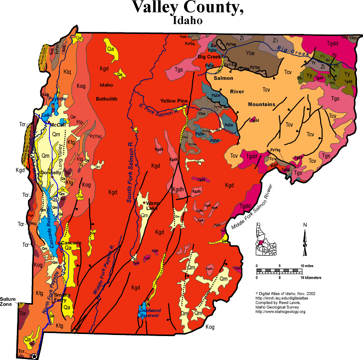
Valley County
Valley County covers a huge area in central Idaho, from Long Valley and McCall east to the Middle Fork of the Salmon River. The South Fork of the Salmon divides the county in two, flowing north toward the Main Salmon river, which is north across the border in Idaho county. The Payette River drains southward in the western part of the county.
On the extreme northwest are accreted terrane rocks west of the Idaho suture zone.
East of the suture are Cretaceous tonalites and orthogneiss of the Idaho batholith, which pass eastward to granodiorite that underlies the bulk of the county. A few inliers of Proterozoic and Paleozoic sedimentary rocks remain, as roof pendants to the batholith.
On the northeast is a downdropped block, the Thunder Mountain caldera, filled with Eocene Challis volcanic group rocks. North of this block of volcanic rocks is a northwest trending belt along Big Creek that exposes Mesoproterozoic Belt Supergroup strata and unique Neoproterozoic intrusive rocks.
Miocene and younger north-striking faults, part of the Basin and Range system, cut the batholith of the central part of the county, and form the Long Valley graben near Cascade Reservoir and Payette Lake.
Geology near McCall
Three major rock groups are exposed near McCall, Idaho. These include: the Cretaceous Idaho batholith, the Triassic-Jurassic metamorphosed island-arc sedimentary and volcanic rocks of the Seven Devils Group and the Miocene flood-basalt flows of the Columbia River Basalt Group. Several structural features are prevalent in the area and most likely control along with the past glaciation the geomorphology in the region.
Structurally, McCall is situated at the end of Long Valley, a major tectonic and structural feature of west central Idaho. The West Mountain escarpment is the high ridge formed along the west side of the Long Valley fault. West Mountain and Long Valley are part of a group of linear north-south ranges and valleys formed by block faulting during the late Tertiary and Quaternary. As West Mountain rose and Long Valley subsided, as much as 7,000 feet of alluvium accumulated in the valley (Idaho Geological Survey website http://www.idahogeology.org/FieldWorkshops/WestCentralIdaho/McCall.htm.)
Glacial deposits are divided into two categories on the basis of origin. "Till" is unsorted, rounded glacial sediments which commonly form moraines. Moraines can be one of four types. "Lateral" moraines are formed from the large accumulations of unsorted debris at the glacier-valley wall interface. "Medial" moraines form when two glaciers merge, and their lateral moraines are incorporated into the center - or medial portion - of the glacier, much like when two streams come together. A "Terminal" moraine is one that marks the furthest advance of the glacier; each farther-reaching advance wipes out the previous terminal moraine. "Recessional" moraines mark periods when the glacier is retreating - that is, the end of the glacier (the snout) where moraine is being deposited is short of the terminal glacier. It is important to remember, however, that even when a glacier is retreating the ice and sediment movement is always forward. In terms of glacial sediment transport, a glacier is not unlike a conveyor belt that can lengthen and shorten as conditions mandate.
The second category of glacial deposit is not formed by flowing ice, but flowing water and is referred to as outwash. "Outwash" is deposited by meltwater discharging at the base of glaciers. Outwash from glaciers commonly forms expansive braided stream networks downvalley from glaciers and differ from moraines in that outwash sediments are well-sorted. For further information on glaciers and glacial geomorphology, please visit the USGS website http://pubs.usgs.gov/gip/glaciers/glaciers.pdf .
Glacial features can be found around the area as most of the broad, high elevation region north of McCall was buried by an ice cap during the Pleistocene. Payette Lake and Little Payette Lake were formed as a result of glaciation in the region as valley glaciers carved the basin and deposited the moraines which impound the lakes. Other glacial geomorphic features, such as cirques - the alpine headwalls where glaciers begin - and medial moraines, around the area are visible in the landscape. An example would be Timber Ridge which formed originally as a large prominent medial moraine. Meltwater streams from these glaciers coursed across the valley depositing thick deposits of sand and gravel that can be seen as high terraces above the Payette River. These terraces are relict valley floors that have been incised as the post-glacial climate has changed and discharges in the Payette drainages have diminished.
See Winston et al. article in Guidebook to the Geology of Eastern Idaho.
Tamra Schiappa and P.K. Link, 10/02
Additional Reading
Rocks Rails and Trails: page
References on Idaho Geology
Click here to see a correlation of geologic units, and the associated time scale.
Click here for a printable version of this map.
Click here for a discussion of the geology of Valley County (PDF)
|
Click on the button below to search the IdahoGeologic
Survey's index of Geologic Maps
|
 |