Geologic Units |
|
| Quaternary alluvial deposits | |
| Quaternary surficial cover, fluveolian cover on Snake River Plain, alluvial fans (Snake River Group) | |
| Quaternary landslide deposits (only Weiser area) | |
| Tertiary sedimentary rocks, undifferentiated | |
| Miocene basalt (basalt of Weiser and basalt of Cuddy Mtn.) (split with Tpb is at 5 Ma) (includes rocks shown as Tpb (Bond, 1978) in Owyhee County and Mt. Bennett Hills | |
| Miocene basalt (Columbia River Basalt Group) | |
| Izee Terrane | |
| Dioritic, gabbroic, granitic, and amphibolitic rocks of the Blue Mountains island arc terrane | |
| Felsic plutonic rocks intruded into the accreted terranes of western Idaho (includes tonalite and trondhjemite and granodiorite) | |
| Olds Ferry Terrane | |
| Baker Terrane |
| Map Key | |
| Geologic units with unit designation. | |
| Normal Fault: certain; dashed where approximately located; dotted where concealed. | |
| Thrust Fault: certain; dashed where approximately located; dotted where concealed. | |
| Detachment Fault: certain; dashed where approximately located; dotted where concealed. | |
| Interstate Route. | |
| U.S. Route. | |
| State Route. | |
| Location of Rockwalk rock from the county. | |
| Cities. | |
| Feature location. |
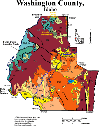
Washington County
Washington County covers a large area on the south slopes of the Seven Devils Mountains and across the Weiser River Valley. It is entirely underlain by accreted terrane rocks, but these are only exposed along the western border, in the canyon of the Snake River.
Much of the central and eastern parts of the county are underlain by Miocene Columbia River basalt flows, cut by normal faults into gently tilted blocks.
The Weiser River Valley contains Miocene sandstones deposited in rivers draining the Idaho batholith in the last 10 million years. These contain mercury deposits east of Weiser.
The geology of the region between Riggins and Boise to the south reflects a long history of plate boundary interactions and terrestrial responses. Exposed along this route is the eastern edge of the Miocene Columbia River Basalt and associated sedimentary units, the western edge of the extensive plutonic rocks that comprise the late Cretaceous Idaho Batholith, and metamorphosed sedimentary and volcanic rocks of the Jurassic Seven Devils group.
During the Jurassic, an oceanic trench formed off the western margin of North American near the present western Idaho border. North America was moving west, away from the mid-Atlantic oceanic ridge. As the North American continental plate moved westward, the Pacific oceanic plate slid beneath it, and thus beneath the location of the future Idaho. Riding on top of the Pacific oceanic floor were numerous island arcs that eventually were emplaced onto the western margin of North America - prime examples of these emplaced volcanoes are the Seven Devils along Hells Canyon.
These rocks are visible in Hells Canyon, along US Hwy 95 outside of Riggins, and along State Hwy 55 and US Hwy 95 near New Meadows. Other geologic features that are visible along US Hwy 95 are Miocene Columbia River Basalts, deposited from fissure eruptions, and Miocene-Pliocene sedimentary units deposited as the result of stream blockage which occurred as streams were dammed up by basaltic flows.
Additional information on the Idaho Batholith can be found in the description of the geology of Boise County. For more information on plate boundaries and plate motions, please visit the USGS website http://geology.er.usgs.gov/eastern/tectonic.html. For more information on the Columbia River Basalts visit the University of North Dakota Volcano World website http://volcano.und.nodak.edu/vwdocs/volc_images/north_america/crb.html.
An important reference to the geology of the Hells Canyon is U.S. Geological Survey Professional Paper 1438, Geology of the Blue Mountains region of Oregon, Idaho, and Washington; petrology and tectonic evolution of pre-Tertiary rocks, edited by T.L. Vallier and H.C. Brooks.
Excellent discussion of the geology of this area is found in Orr, W.N., and Orr, E.L., 2002, Geology of the Pacific Northwest, 2nd ed., McGraw Hill Pubs., p. 138-159.
Good information is also contained in Alt, D. D., and Hyndman, D.W., 1989, Roadside Geology of Idaho, Mountain Press, Missoula, 393 p.
Tamra Schiappa and P.K. Link, 10/02
Additional Reading
Rocks Rails and Trails: page
References on Idaho Geology
Click here to see a correlation of geologic units, and the associated time scale.
Click here for a printable version of this map.
Click here for a discussion of the geology of Adams, Washington and Southern Idaho Counties (PDF)
|
Click on the button below to search the IdahoGeologic
Survey's index of Geologic Maps
|
 |