Click
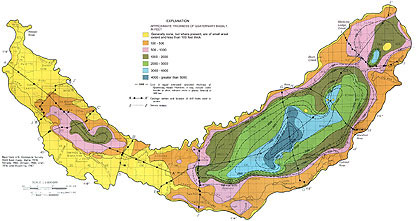
here for a full-sized basalt thickness diagram.
CLICK on the titles below to view full-sized basalt cross-section diagrams:
Several hundred to several thousand feet of quaternary basalts of the Snake River Group underlie much of the Snake River Plain. Basalt thickness is known from only a few drill holes and is estimated elsewhere by geophysical methods. As a result variations in thickness shown on the map and on cross-sections approximate and speculative in some areas. These younger basalts are the most permeable units of the Snake River Group and, where saturated (dashed contours), comprise the most productive part of the Snake Plain aquifer.
Miocene Banbury Basalt of the Idaho Group and the Miocene Columbia River Basalt Group or equivalent Miocene basalt underlie or flank much of the western plain and part of the eastern plain. In several areas, Banbury Basalt or basalt of equivalent age is separated from the basalts of the Snake River Group by sedimentary rocks several tens to several hundreds of feet thick. These older basalts are, in general, much less permeable than the younger basalts. Reduced hydraulic conductivity with depth has been observed in several deep drill holes and is, in part, due to secondary mineralization.
Elsewhere in the eastern plain, silicic volcanic rocks (chiefly Quaternary and Tertiary rhyolite) underlie the younger basalts.
Kuntz and Dalrymple (1979, p. 5) suggested that much of the Quaternary basalt was extruded along fractures normal to the plain's axis. In the eastern plain, these zones of weakness may be extensions of Basin and Range structural features that are adjacent and normal to the plain's axis. Profiles based on vertical electrical soundings tend to support this theory. Basalt vents may be indicated where high resistivity zones extend downward several thousand feet below the apparent average basalt thickness in the area. However, it is recognized that these zones may be the result of instrument limitations rather than rock type.
A map of the estimated saturated thickness of Quaternary basalt (dashed contours above) was made using the above basalt thickness map, topographic maps, drillers' logs, and a water-table contour map drawn by Lindholm, Garabedian, Newton, and Whitehead (1983). The above map does not indicate the total aquifer thickness. The map excludes stratigraphically equivalent sedimentary and volcanic rocks of Holocene to late Tertiary age. Thus, the regional aquifer, particularly along the margins of the plain, is considerably thicker than the saturated basalt shown above. Interbedded sedimentary and other volcanic rocks occurring in thin zones of small aerial extent may be included with the Quaternary basalt in places.
For example, northeast and southeast of Arco, small areas of Tertiary silicic volcanics are shown completely surrounded by younger Quaternary basalts. Very little is known about subsurface conditions in these areas. Vertical electrical sounding data indicate high-resistivity materials at depth. The silicic volcanics may extend to considerable depths, and if in the form of volcanic flow rock, its electrical resistivity would be similar to that of Quaternary basalt. If so, in areas of isolated silicic volcanics, no distinction is possible between younger basalt and older volcanic rocks.
Geologic sections show the predominance of quaternary and tertiary volcanic rocks in the upper several thousand feet of the eastern Snake River Plain. Sedimentary rocks of equivalent age predominate in the western plain. Structurally, the western plain is a graben; bounding faults shown on the sections as single lines represent fault zones. In much of the plain, most wells are completed in the upper several hundred feet of the aquifer; thus, little is known about deeper parts of the aquifer. Where deep drill holes were lacking, rock distribution was estimated using geophysical methods.
The north wall of the Snake River canyon from Milner to King Hill was mapped by H. R. Covington (U.S. Geological Survey, written communication, 1983), as part of the present study to determine geologic controls with respect to spring locations and amounts of discharge. Many of the springs issue from old river channels filled with pillow lavas. As lava flows dammed and subsequently flowed into water-filled channels of the ancestral river, they cooled rapidly and formed pillow lava. Pillow lavas range texturally from sands to boulders, are extremely permeable, and readily transmit large quantities of water. Springs issue from the present Snake River canyon wall at the contact between pillow lava and underlying less permeable rocks. The sedimentary rocks immediately underlying Quaternary basalt in section E-E' are assumed to extend to the north canyon wall where they are obscured by basaltic talus slopes. Contacts between these sedimentary rocks and overlying and underlying basalts are most likely irregular rather than horizontal.
At cross-section J-J' seismic data suggest considerable relief on the surface of the Miocene basalt underlying the western Snake River Plain. The section is a modification of sections prepared by Wood and Anderson (1981, p. 14-15) showing interpretation of seismic reflection data, wherein dense Miocene basaltic rocks form the seismic "basement." This basalt is considered to be highly faulted. Data from gravity surveys (Hill, 1963, p. 5813) and a few deep drill holes suggest that Miocene basalt underlies the entire western plain and extends into the eastern plain. A 14,000-ft drill hole (NEI/4SEI/4SEI/4 sec. 27, T. 4 N., R. 1 W., shown -on - the section above) penetrates the entire basalt unit, which at that location, is about 7,000 ft thick. Malde (1959, p. 272) suggested that the thickness of the dense basalt unit may exceed 30,000 ft in places. Interbedded with the basalt but diminishing with depth are small amounts of sedimentary and tuffaceous rocks.