
Maps & Globes
 |
 |
| Remember: Earth is tipped on its axis of rotation (relative to our plane of orbit around the sun). |
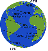
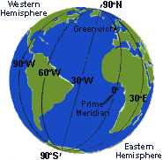
Latitude and Longitude are cartographic lines superimposed on the surface of the earth. These lines create a grid coordinate system that is used to pinpoint locations on earth - each point on the globe is assigned an unique pair of longitude and latitude values so that it may be identified easily and accurately. Latitude lines (or parallels) run from east to west horizontally around the globe. Longitude lines (or meridians) run vertically from the North and South Poles.
Like other circles, latitude and longitude are measured in units of degrees, minutes, and seconds with a total of 360 degrees possible (1 degree = 60 minutes and 1 minute - 60 seconds). A protractor can be used to measure these distances.
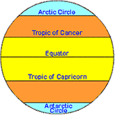
Longitude values range from 180 degrees west to 180 degrees east, and are measured from the Prime Meridian, or zero degrees longitude (the longitude line passing through Greenwich, England). The longitude line directly opposite to the Prime Meridian is called the International Dateline and can be considered as either 180° east or west). The Equator is the line of latitude that divides the globe into two equal halves, the Northern and Southern Hemispheres. The Equator is designated as 0° latitude. Latitude is measured North or South of the Equator with a range of 0 to 90 degrees. Latitude lines below the equator have negative values, while those above the equator have positive values. The full range of latitude values then is -90 (S) to +90 (N) degrees. Some familiar examples:
 1.
The Tropic of Capricorn (23.5 degrees S)
2. The Antarctic Circle (66.5 degrees S)
3. Tropic of Cancer (23.5 degrees N)
4. The Arctic Circle (66.5 degrees N).
Look at how the curvature of the earth affects the shape of the latitude and longitude lines. All of the longitude lines are identical so degrees of longitude are constant, always covering the same distance (about 60 nautical miles). In contrast, degrees of latitude vary. Near the equator, a degree of latitude is approximately 60 nautical miles, but as you approach the poles that distance goes to zero.
It is important to keep in mind that the earth is curved and maps are flat, so they do not quite represent reality. To properly map the earth, a planet shaped globe is required. Cartographers represent the curvature of the earth on a flat surface by means of a projection. Regions are projected on to a map in different ways in order to correct for real direction, area or shape. The most common projection used is the Mercator, which was invented in 1568 by the German Gerhard Kramer (a.k.a. Gerardus Mercator). The Mercator distorts the size of the continents however because it makes the earth the same width at the at the equator and the poles.
The
Data Behind a Map
Reference
Datum: A reference datum is a known and constant surface which can
be used to describe the location of unknown points. On Earth, the normal reference
datum is sea level. On other planets, such as the Moon or Mars, the datum is
the average radius of the planet.
Map Projections: A map projection is a way of representing the 3-dimensional surface of the Earth on a flat piece of paper.
Distortion: Each of the different types of projections have strengths and weaknesses, and knowledge of the advantages and disadvantages of a particular map projection will often help you to choose what map you want to use for a particular project.
Grid systems: A grid system allows the location of a point on a map (or on the surface of the earth) to be described in a way that is meaningful and universally understood.
Coordinate systems: There are several types of grids (a.k.a. coordinate systems) used to divide the earth’s surface. Four of these are in common use on maps published in the United States: geographic, universal transverse mercator (UTM), state plane, and public land survey coordinate systems.
Much of the information discussed above is applicable to all types of maps.