|
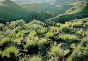
| Basalt rim overlook, Big Jack's Creek Canyon, Owyhee Plateau. |
The Owyhee River and Bruneau River basins lie in southwestern Idaho, southeastern Oregon, and northern Nevada. This basin encompasses approximately 11,340 square miles of semi-arid, high desert country, of which about 8,000 square miles lies within Idaho. In the higher bench lands of the Bruneau and Owyhee, the rivers and their tributaries flow through deeply incised canyons. Elevations in the Owyhee drainage range from 8,100 feet in the Owyhee Mountains to 2,400 feet at the Snake River. The Owyhee River has an annual average discharge of 661,500 acre-feet of water at the Oregon/Idaho border. Elevations in the Bruneau drainage range from over 10,000 feet in the Jarbidge Mountains to 2,455 feet at the mouth. The Bruneau River has an annual average discharge of 292,000 acre-feet of water.
Most of the Owyhee River drainage contains excellent populations of redband trout. A Bureau of Land Management resource inventory identified redband trout in 23 of 27 perennial streams and 7 of 15 intermittent streams.
Lahontan cutthroat trout have been introduced into several reservoirs near Riddle.
No cutthroat trout are present in the Bruneau River drainage. A remnant population of bull trout exists in the Jarbidge River. Populations of native redband trout exist in many tributaries. Redband trout are widely distributed, however, some local populations have been severely affected by land management activities and drought.
From the mouth of the Bruneau River upstream to the hot springs, the water quality is not suitable to support coldwater species.
The Bruneau River, West Fork, lower East Fork, lower Sheep Creek, and Jarbidge River have been recommended for National Wild Rivers status.