|
Page
24
|
|
||
|
||
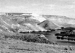
| View of Hagerman Fossil Beds National Monument, which includes the light-colored cliffs on the west side of the Snake River near Hagerman. The sediments that bear hundreds of different species of fossils are about 3 to 4 million years old and belong to the Pliocene Glenns Ferry Formation, (May, 1995) . | ||
|
||
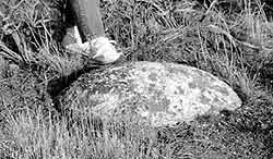
| Boulder carried by an iceberg in the Big Lost River flood about 17,000 years ago. This picture was taken south of Arco, near the route of the Goodale Cutoff (March, 1995). The 2 foot diameter boulder was carried from the Copper Basin area in the Pioneer Mountains, a distance of almost 100 miles. |
Lakes
on the Snake River Plain
As the western Snake
River Plain subsided in the wake of the passage of the Hot Spot, large fresh
water lakes and river flood plains formed. These have been generally grouped
under the rather fuzzy concept of "Lake Idaho." Fossils of now-extinct
mammals, especially an early horse, are found at Hagerman Fossil Beds National
Monument west of Hagerman. The light-colored sands and silts contain river channel
deposits in which several complete skeletons of horses and other large animals
have been found.
Glaciation
in the Mountains of Idaho
The Pleistocene (the last
2 million years) has been a time of climatic conditions alternating between
glacial and non-glacial, with a periodicity of about 100,000 years. There are
also smaller cycles with periodicities of a few thousand years. In conjunction
with a lowering of the earth's temperature by a few degrees, snow fields have
built up, and reflectivity and cloudiness have increased.
During the cooler and wetter parts of the cycles, glaciers formed in the higher mountains of Idaho. The Yellowstone Plateau and Jackson Hole areas were extensively glaciated, as were the Sawtooths, Pioneers, the high Lost River, Lemhi, and Beaverhead Ranges to the east and the Albion Range south of the Snake River Plain. In the Wyoming Rockies, the last two glacial advances are termed "Bull Lake" (maximum about 140,000 years ago) and "Pinedale" (maximum about 20,000 years ago). In the Copper Basin area these advances are termed "Copper Basin" and "Potholes," and in the Wood River Valley they are called "Prairie Creek" and "Boulder Creek" (Evenson and others, 1982; Evenson and others, 1988). An earlier, pre-Bull Lake advance is named the "Pioneer" glaciation.
During glacial advances, ice builds up and flows down valleys. At the terminus and sides of valley glaciers, poorly sorted sediment is deposited in moraines. In front of the glaciers, abundant meltwater flows downstream. This sediment-charged water deposited the high-level river terraces present today in the valleys of the Big Lost and Big Wood Rivers.
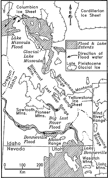 |
Map showing areas of Idaho affected by latest Pleistocene glaciation and the Bonneville, Missoula and Big Lost River Floods (slightly modified from Cerling and others, 1994). Glaciation was present both north of the Snake River Plain and in the Albion Range south of the Plain. Click on image for larger view. |
Big
Lost River Floods
Recent work
has determined that the Big Lost River flooded one or more times, carrying boulders
from the Copper Basin area all the way to the Snake River Plain at Box Canyon
south of Arco (rathburn, 1993). The last of these floods occurred about 16,000
years ago, at the same time as the Lake Missoula floods in northern Idaho and
over two thousand years before the Lake Bonneville Flood in southern Idaho (O'Connor,
1990, 1993). Such Pleistocene floods are part of the mythology of cultures from
around the world.