Page
80
|
Page
80
|
Mormon
Colonization
In 1869, Brigham
Young invested in 650 acres of land, including part of the present Soda Springs
townsite. In June 1870, Young and a contingent of Mormons visited Soda Springs
with an eye toward colonization. A lodging house for Young and his family was
built overnight by 20 volunteers from Paris. Gold was discovered at Carriboo
Mountain, north of Soda Springs, later that year. The first permanent Mormon
settlers arrived in Soda Springs in the spring of 1871. Also in 1871, the Utah-Northern
Railroad Company, a project of the Mormon church, was started north from Brigham
City, headed for Soda Springs by way of Franklin, and ultimately to the mines
near Butte, Montana.
A
Wild Frontier Town
By the time
Oregon Short Line Railroad Company reached Soda Springs in 1882, the town was
a wild frontier community. It served as the railhead for a huge area of mountains
and forest to the north, over which ranged miners starting in 1870, cattlemen
starting in the 1880s, and sheepherders starting in the 1890s.
 |
 |
 |
|
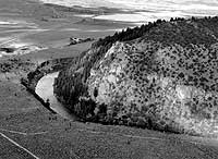
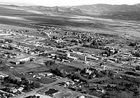
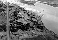
(left) Soda Point or Sheep Rock, looking east. Soda Point reservoir and city of Soda Springs are in the background. The Bear River here makes almost a 180° bend and flows southward into a canyon cut in Pleistocene basalt. Also at this point the Oregon Trail headed northwest while the Hudspeth Cutoff headed straight west across Gem Valley, (June, 1992). (center) Aerial view of Soda Springs, looking southeast, (June, 1992). Geyser is on the extreme right middle side of photo, one block west of Main Street, which runs diagonally through the right foreground of photo. Idan-ha' hotel stood east of Main Street, just north of the railroad tracks and west of the grain elevator. Soda Creek in foreground. (right) View looking east along Oregon Trail and U.S. Highway 30 just west of Soda Springs. Soda Point (alexander) Reservoir is on the right, and was the original site of the 1863 Morrisite settlement of Soda Springs. Union Pacific Railroad is just out of the view to the left. Oregon Trail followed a route just north (left) of the reservoir. Prominent scar between Oregon Trail and the Highway is a natural gas pipeline, (June, 1992). |
||