|
Page
110
|
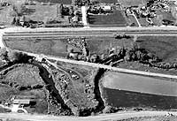
(left) Portneuf River at Blackrock, looking north, (June, 1992). The arched stone bridge over the river in the center was built over the original Utah & Northern bridge. Old Bannock Highway is in foreground; Old Highway 30 and double track Union Pacific tracks are in upper part of picture.
(center) Utah & Northern grade along Marsh Creek, looking east between McCammon and Inkom near Indian Rocks Park. The right of way can be seen at the foot of the basalt flow, on the far side of the river. It was this part of the grade that was prone to flooding, (June, 1992).
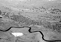
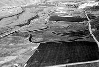
(upper right) Aerial view looking east toward the city of Inkom. Old Union Pacific quarry is on the right, where Late Proterozoic quartzite was mined for railroad ballast. The faint trace of the Utah & Northern right of way can be seen in the central part of the view, crossing the Portneuf River on a frame bridge in left center of photo. This picture also shows the sharp meanders of the Portneuf River and the two lava flows (on the left), (June, 1992).
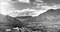
(middle right) Portneuf Narrows and Portneuf School. View looks east, 1920s. Cook photo, Bannock County Historical Society Collection.
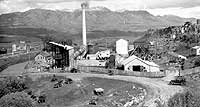
(bottom right) Original Inkom cement plant, looking east at Mount Bonneville, early summer, (1929). Cook photo, Bannock County Historical Society Collection.