|
Page
151
|
|
|
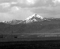 |
| Bannock
Peak at the north end of the Deep Creek Mountains, looking west from Rattlesnake
Creek. The distinctive peak can be seen for miles, even though it is less
than 9,000 feet high. It is composed of thrust-faulted Paleozoic rocks,
(May,1996). |
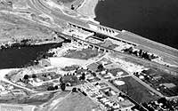 |
| Aerial
view, looking northwest at American Falls Dam and the bridge of the Union
Pacific Railroad. Note that the reservoir water is at about 1/3 of its full
level, (august, 1989). |
 |
| Aerial
view looking north across the Snake River at Duck Point and the island Eagle
Rock, southwest of American Falls. Duck Point was the site of the lava flow
dam to the ancestral American Falls Lake. The white beds on the north side
of the river in the middle distance are American Falls Lake Beds. The area
was scoured by the Lake Bonneville Flood. Lake Channel is a few miles to
the west of the photo. The irrigated farmland in the background is west
of Aberdeen, (august,1989). |
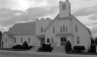 |
| Mennonite
Church, Aberdeen (April 1996). Left side of the church is the original structure,
built in 1910. |
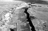 |
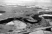
| Aerial
view of Lake Channel, looking north. The Lake Bonneville Flood cascaded
into this canal in the alcoves of now dry waterfalls in the right distance
and flowed south toward the camera toward the Snake River, (august, 1989). |
American
Falls Lake
The ancestral American Falls
Lake formed north of a basalt dam that formed at Duck Point, east of Massacre
Rocks, about 72,000 years ago. The ancestral lake covered a larger area than the
present one, and may have reached into what is now downtown Pocatello. The American
Falls "lake beds" contain a lower fluvial member and an upper light-colored
clay member deposited under water of a perennial lake. The flood plain and lake
margin sediments contain a unique assemblage of Pleistocene mammal fossils, including
Bison latifrons, camels, short-faced bears, ground sloths, horses and mammoths.
They overlie an older sequence of lake beds known as the Raft Formation. Early
reports concluded that the American Falls Lake existed at the time of the Lake
Bonneville Flood and was drained catastrophically by it (malde, 1968). Recent
geological studies favor the view that a flood plain and fluvial complex had developed
on the American Falls Lake beds by the time of the Lake Bonneville Flood (Hearst,
1990).
Michaud
Flats and Lake Channel
The Lake
Bonneville Flood about 14,500 radiocarbon years ago deposited a flat-topped
delta of boulders, gravel, and sand in the area of Michaud Flats, up to an elevation
of about 4,400 feet near the Pocatello airport. The flood waters cut "Lake
Channel," a now-dry channel north of the Snake River and west of present
American Falls Dam, which provided a means for the floodwater
to escape the flat American Falls area.
Several other
smaller channels exist near Lake Channel, but they carried less water and were
abandoned when the main Snake River cut the basalt dam at Duck Point, allowing
the floodwaters to follow the present Snake River. The water from Lake Channel
emptied back into the Snake River just west of and across the river from Massacre
Rocks State Park.
Oregon
Trail near Massacre Rocks
The Oregon
Trail followed the south side of the Snake River from the Fort Hall area across
Idaho to Three Island Ferry. At Massacre Rocks, west of American Falls, and
at other areas west of there ruts of the trail are still visible.
|
Oscar Sonnenkalb
wrote:
"American
Falls was for many surrounding miles the only oasis for the thirsty
cowboy, sheep men and the farmers from scattered ranches, turning in
from the wild outdoor life to enjoy a day of two of social life spiced
with poker playing, improvised horse races and endless drinking bouts.
Whenever I had a call from American Falls for some surveying work to
be done, some drastic occurrence had just been played off; a free-for-all
fight in the saloons, a dueling or wounding with knife or pistol, some
wild rides through the streets and painting and shooting up the village.
A good many of these feats seemed to be considered, by the natives at
least, are quite harmless, and in fact were mostly mere pranks of whiskey
loaded rowdies, but for the outsider and the eastern traveler these
wild tournaments were considered to be quite serious affairs."
(Harstad, 1972, p. 21.)
|
American
Falls
The town
of American Falls grew up during construction of the Oregon Short Line Railway
and became a major center for the wheat and stock growers of the area south
and west of Pocatello.
Part of the old town
of American Falls was moved in 1926 to higher ground during construction of
the reservoir. Only the top of the grain elevator now pokes above the waters
of the lake. In late summer when the water of the reservoir is low, foundations,
sidewalks, and tree stumps of the old town are accessible.
|
American Falls itself,
before the construction of the dam, was 800 feet wide with a drop of 50
feet over 200 feet. Oregon Trail pioneer Bryan McKinstry wrote in July
1850 that the water as it descends over the falls,
"works itself
into a perfect fury, throws the spray into the air like rain which strikes
you in the face, and when the sun shines forms a beautiful rainbow."
.
|
Aberdeen
Farmland
near Aberdeen was initially settled, starting in 1906, by Mennonites from Newton,
Kansas. Salesmen from the Twin Falls area had gone to the midwest and spoken
to church groups about the new opportunities for irrigated farming on the Snake
River Plain. The Mennonites are a sect of Anabaptist
Christians, originally from Germany, who, because of their pacifist refusal
to serve in war, were forced to flee from Holland and Germany to Poland and
Russia, and later to immigrate to America. Building of irrigation canals allowed
settlement of the Aberdeen area, and the town was incorporated in 1908, named
for Aberdeen,Scotland.
The railroad branch line
from Blackfoot, started by the Salmon River Railroad Co., but completed by Union
Pacific, was completed in 1911. Also in 1911, The University of Idaho established
the Aberdeen Agricultural Experiment Station. The next ten years
were boom years.
The drought and agricultural
depression of the 1920s and 1930s followed. The flooding of the American Falls
Reservoir, in 1926, cut off the direct road across the Snake River to Pocatello.
The town today remains quiet and agricultural, though Mennonites are no longer
in the majority.
top