Page
161
Settling
of Oakley
The largest
group of LDS migrants into south-central Idaho was the one that founded Oakley
and other towns in the Goose Creek valley. This migration began in 1879 and
consisted of residents mainly from Tooele and Grantsville, Utah. Oakley quickly
became the headquarters for the Mormon community in southern Idaho. Horton David
Haight, a veteran of the Mormon settlement at Nauvoo, became the first bishop
of Cassia Ward. His father was the first settler of Farmington, Davis County,
Utah. Haight served as first president of the Cassia stake from 1887 to 1890.
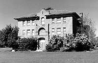
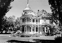
The children from the union of Horton and Louise Haight became prominent citizens
of early day Oakley and built most of the large brick houses which still stand.
Victorian style architecture was still in vogue there, in the 1890s, even if
it had lost its popularity in the rest of the U.S.
By the time other Magic Valley communities developed, twenty years later, bungalows and cottages were the architectural standard.
In 1905, Oakley had 2,000 people. Rails came in 1910. The town, in the 1990s sits at the western gate to the Silent City of Rocks and has potential as a tourist center, even though such catering to the whims of long-haired out-of-state rock-climbing tourists is antithetic to the ideological foundations of the city.
 |
Raft
River Valley
In the
early 1800s, Raft River was a deep stream that inconvenienced trappers and travelers.
Today it is depleted by upstream irrigation and is a muddy ghost of its former
self.
A major effort at exploration for geothermal energy was made in the 1980s in the Raft River Valley south of Malta. A pilot plant for production of electricity by geothermal means was constructed by the Department of Energy, but the effort has not proven economically feasible.
Burley
Burley
was settled in about 1910, as the headquarters for the Minidoka and Southern
Railroad, and named for the first rail agent. Union Pacific completed building
of the Twin Falls Branch line after taking over the Minidoka and Southern. The
flat and productive fields between Oakley and Burley are irrigated with water
from Goose Creek Reservoir, to the south of Oakley.
References
Arrington, L.J., 1979, The Mormon Settlement of Cassia County, Idaho 1873-1921: Idaho Yesterdays, v. 23, no. 2, p. 36-46.
Bandy, Philip J., 1992, Structural and kinematic analysis of the City of Rocks lobe of the Almo Pluton, Cassia Co., Idaho: An application of granite tectonics [M.S. thesis]: Pocatello and Boise, Idaho: Idaho State University and Boise State University, 105 p.
Madsen, B. D., 1993, The "Almo Massacre" revisited: Idaho Yesterdays, v. 37, no. 3, p. 54-64.
Maley, Terry, 1987, Exploring Idaho Geology: Mineral Land Publications, P.O. Box 1186, Boise, Idaho, 83701, 232 p.
Maughan, Ralph W., 1992, Anatomy of the Snake River Plain: An Amateur's View, Pocatello, Idaho: The Idaho State University Press, 69 p.
Miller, David M., Armstrong, R.L., Compton, R.R., and Todd, V.R., 1983, Geology of the Albion-Raft River-Grouse Creek Mountains area, northwestern Utah and southern Idaho: in Gurgel, K.D., editor, Geologic excursions in the overthrust belt and metamorphic core complexes of the Intermountain region: Utah Geological and Mineral Survey Special Studies 59, p. 1-63.
Mytton, James, W., Williams, Paul L., and Morgan, William A., 1990, Geologic map of the Stricker 4 Quadrangle, Cassia County, Idaho: U.S. Geological Survey Miscellaneous Investigations Series, Map I-2052, scale 1:48,000.
Saltzer, S.D., and Hodges, K.V., 1988, The Middle Mountain Shear zone, southern Idaho: Kinematic analysis of an early Tertiary high-temperature detachment: Geological Society of American Bulletin, v. 100, p. 96-103.
Wright, Bessie, M., Oakley, Idaho, Cassia County, Pioneer Town: 1987, Horizon Publishers, Bountiful, Utah, 211 p.
Williams, P.L., Covington, H.R., and Pierce, K.L., 1982, Cenozoic stratigraphy and tectonic evolution of the Raft River Basin, Idaho: in Bonnichsen, B., and Breckenridge, R.M., eds., Cenozoic geology of Idaho: Idaho Bureau of Mines and Geology Bulletin 26, p. 491-504.
Williams, P.L., Mytton, J.W., and Covington, H.R., 1990, Geologic map of the Stricker 1 quadrangle, Cassia, Twin Falls, and Jerome Counties, Idaho: U.S. Geological Survey Miscellaneous Investigations Series Map I-2078, scale 1:24,000.