|
 (top
left) Old Hansen suspension bridge over the Snake River, opened in 1919.
It was originally two lanes, but as cars became wider the bridge was reduced
to one lane. The old bridge was replaced with the present concrete bridge
in 1966. Abe Lillibridge collection, Idaho State University. (top
left) Old Hansen suspension bridge over the Snake River, opened in 1919.
It was originally two lanes, but as cars became wider the bridge was reduced
to one lane. The old bridge was replaced with the present concrete bridge
in 1966. Abe Lillibridge collection, Idaho State University.
(top
center) Snake River Canyon at Murtaugh Bridge, looking west, downstream.The
town of Murtaugh is immediately to the left of the view. Note the scoured
Bonneville Flood path, on which there is not enough soil to grow even
irrigated crops. Caldron Linn is just upstream (to the right) from here,
(July, 1989).
(top right) Aerial
view looking west, (June, 1991), of the Lake Bonneville Flood path near
Murtaugh east of Twin Falls. The south branch of the flood followed the
Snake River Canyon here while the farmland to the north of the river was
not eroded by the flood waters. The north branch of the flood passed through
the scoured basalt in the far right distance. The Hiline Canal can be
seen to the south of the river.
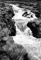
(mid center) Caldron
Linn, a narrow waterfall along the Snake River west of Milner Dam. The
name was chosen by the Hunt Party of Astorians,who in 1811 abandoned their
attempt at navigating the Snake at this place.The word "Linn"
is an old Scottish word for waterfall. The boiling waters were likened
to a caldron (cauldron). During low water a person can almost jump over
the river at the narrowest point, (March, 1993).
(mid right) Twin Falls,
125 feet high, before 1910. A power plant now blocks the right (south)
channel. Abe Lillibridge collection, Idaho State University Library.
(bottom right) Shoshone
Falls in one of the rare times of high water flow, (May, 1983). The falls
are cut in rhyolite lava beneath the basalt cap of the Snake River Plain.
Photo was taken near the site of a hotel built for railroad visitors from
Shoshone in1886. This was replaced by a larger hotel in 1890 which, in
later years, was served from Twin Falls by an electric interurban line.
|