 Response
functions cannot be universally applied to all situations. The validity
of response functions is linked to the concept that responses, such as river depletion
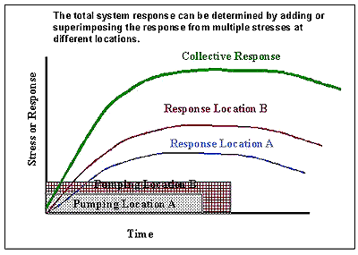
from pumping, are additive and proportional to the pumping or recharge rate.
This assumption is valid in many ground water environments. Each situation
should be evaluated by a qualified professional hydrologist, however, to determine
if any of the following excluding conditions are likely to have a significant
effect on the ground water flow system in the area of interest.
Response
functions cannot be universally applied to all situations. The validity
of response functions is linked to the concept that responses, such as river depletion
from pumping, are additive and proportional to the pumping or recharge rate.
This assumption is valid in many ground water environments. Each situation
should be evaluated by a qualified professional hydrologist, however, to determine
if any of the following excluding conditions are likely to have a significant
effect on the ground water flow system in the area of interest.
EXCLUDING CONDITIONS:
2) Springs either begin or cease flowing as a result of natural or man-imposed changes in aquifer water level.
3) Streams transition between perched and hydraulically connected with the aquifer.
4) Evapotranspiration or other water consumption varies non-linearly with aquifer head.
5) Enough water is flowing in the river to meet demands in losing reaches.
Response functions generated by field measurements, analytical techniques, or numerical models will be burdened with all of the assumptions of the method used in their development. For example, if the Jenkins (1968) analytical technique is used to generate the response functions, then one of the assumptions underlying the response functions is that the stream is straight and fully penetrating. If a numerical model is used to generate the response functions, then the accuracy of the response functions is directly dependent on the accuracy of the numerical model's calibration and the underlying conceptual model. In many cases, this will be the greatest source of error in application of response functions.