Geologic Units |
|
| Quaternary alluvial deposits | |
| Missoula Flood deposits | |
| Quaternary moraine and glaciofluvial outwash | |
| Tertiary sedimentary rocks, undifferentiated | |
| Miocene basalt (Columbia River Basalt Group) | |
| Eocene granodiorite, granite, diorite, and shallow dacitic intrusive | |
| Cretaceous granite and granodiorite of the 2-mica suite (Idaho batholith) | |
| Cretaceous granite and granodiorite of the hornblende-biotite suite (includes megacrystic granodiorite and granite) | |
| Cambrian sedimentary rocks | |
| Neoproterozoic Deer Trail Group | |
| Mesoproterozoic augen gneiss and porphyritic granite | |
| Upper Missoula Group. Upper part Swauger Quartzite (Mount Shields, Bonner, and Libby Fms.) | |
| Lower Missoula Group. Lower part-- Gunsight Formation (Snowslip and Shepard) | |
| Piegan Group or Middle Belt carbonate, Apple Creek Formation (includes Cobalt and Yellowjacket Formations, and Yaq argillaceous quartzite unit of Ekren) | |
| Ravalli Group, includes Hoodoo Quartzite, Big Creek Formation, Yellowjacket Formation, lower part of Lemhi Group | |
| Prichard Formation (Lower Belt), includes Yqcp quartzite and carbonate rocks in Prichard | |
| Schist of the Wallace Formation and lower Missoula Group | |
| Quartzite and calc-silicate gneiss of the Wallace Formation | |
| Quartzite and schist of the Ravalli group | |
| Quartzite and schist of the Prichard Formation | |
| Metamorphic rocks, Elk City metamorphic sequence and related rocks, Syringa metamorphic sequence, and Priest River metamorphic complex | |
| Archean basement |
| Map Key | |
| Geologic units with unit designation. | |
| Normal Fault: certain; dashed where approximately located; dotted where concealed. | |
| Thrust Fault: certain; dashed where approximately located; dotted where concealed. | |
| Detachment Fault: certain; dashed where approximately located; dotted where concealed. | |
| Interstate Route. | |
| U.S. Route. | |
| State Route. | |
| Location of Rockwalk rock from the county. | |
| Cities. | |
| Feature location. |
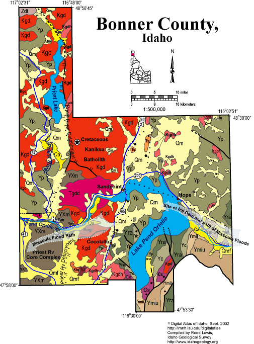
Bonner County
The northern and western parts of the county, west of Sandpoint contain the Priest River metamorphic core complex, containing highly metamorphosed rocks of Proterozoic age. The detachment fault which bounds the core complex runs north along the east side of Priest Lake.Cretaceous intrusive rocks of the Kaniksu batholith (part of the Idaho batholith complex) are found both above and below the detachment fault. Eocene granodiorite intrusive rocks are also found in the center of the metamorphic core. The complex represents recurrent Eocene to Recent uplift.
In the eastern part of Bonner County relatively low-grade metasedimentary rocks of the Mesoproterozoic Belt Supergroup make up the mountains east of Lake Pend Oreille and along the Montana border.
Southeast of Lake Pend Oreille is a small area underlain by Cambrian limestones similar to those mined for lead, zinc and gold near Metaline Washington.
The Lake Missoula flood broke out of the Clark Fork Canyon in the eastern Bonner County about 16,000 years ago, with the ice dam spanning the eastern bays of Lake Pend Oreille. The flood broke out to the south and west of Lake Pend Oreille as it flowed into Rathdrum Prairie and the Spokane River. For more about the Lake Missoula flood click here.
Written by P.K. Link, 9/02
Additional Reading
Rocks Rails and Trails: page
References on Idaho Geology
Click here to see a correlation of geologic units, and the associated time scale.
Take a look at the Sample rock from Bonner county in ISU's County Rock Walk.
Click here for a printable version of this map.
|
Click on the button below to search the IdahoGeologic
Survey's index of Geologic Maps
|
 |