Southern
Idaho Topographic Development
Physiography
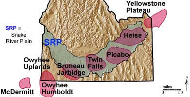
The Snake River Plain is
a broad west-draining lava plateau, with mountains on its north and south sides.
The Plain has the shape of a broad "V" and is divided into eastern
and western parts, which meet near Hagerman, just west of Twin Falls.
The Snake
River drains southwestward, fed by drainage off the Yellowstone Plateau, located
above the Yellowstone-Snake River.
Plain
Hot Spot
The eastern Snake River
Plain is a northeast-trending lowland underlain by rhyolitic volcanic
fields with nested calderas less than 12 million years old, and a thin cover
of basalt less than 2 million years old. The volcanic fields are progressively
younger to the northeast towards the Yellowstone Plateau, reflecting the southwest
movement of the North American plate over a fixed mantle plume. The eastern
plain is bounded by steep north - northwest - trending Basin and Range mountains,
with agricultural valleys between.
Through the
last 12 million years, a dome-shaped topographic high moved northeastward ahead
of the hot spot. This elevated bulge was inflated by hot-spot derived thermal
energy. As the highland moved northeastward, drainage flowed radially away from
it, mainly to the south, north, and east. As the bulge subsided, the west-flowing
Snake River captured drainages like the Portneuf and Big Lost Rivers, and the
Snake River Plain formed. The movement of the bulge also caused the continental
divide to migrate eastward.
The western Snake River
Plain is a north - northwest - trending 10 million year old basin bounded by
normal faults. It is filled with thick sequences of basalt lava, sediments of
Lake Idaho, and stream deposits derived from the Idaho batholith to the north
and the Owyhee Mountains to the south. Both arms of the Plain appear to have
been strongly shaped by extension of the crust on the North American Plate during
the past 17 million years.
Supplemental
Material:
Some
interesting additional reading and diagrams on the Snake River Plain-Yellowstone
Hot Spot are found in Rocks, Rails and Trails: pp. 4,
5, 7,
10, 12,
21-24, 27,
and 107 and
in Chapter 6 on the Snake
River Plain.
Take a look at segments from an essay on: The
Topographic and Geomorphic Development of Southeastern Idaho.
For related Field Guides see Chapter
Three: Snake River Plain (from Guidebook to
the Geology of Eastern Idaho)
Source
Information