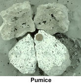
 Pumice:
Pumice is a porous
form of volcanic rock that is used as an abrasive.
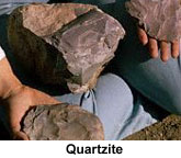
Quartzite:
Quartzite is
a granular metamorphic rock consisting of interlocking grains of quartz -
or silica dioxide. It has the general chemical formula of [SiO2]x.
It is largely used as a building stone. Idaho quartzite is mined in the City
of Rocks area. The most well-known is called "Oakley stone".
Oakley stone is mined from a group of quarries situated on the west flank
of Middle Mountain. This mountain, which terminates several miles south of
the town of Oakley, has the appearance of a tilted fault block with a gentle
slope on the west side and a steep slope on the east side. In the vicinity
of the stone quarries, the crest of Middle Mountain reaches an elevation of
8457 feet. The quarries are situated about half way up the west flank of Middle
Mountain at an elevation ranging from 6000 to 7500 feet.
This rock is unusual because it splits into large flat plates up to 8 feet in
diameter and less than one-half inch thick. Geologists call this stone a micaceous
quartzite because it is composed primarily of quartzite and muscovite mica.

Click
here to
look at a picture of the plates.
Marketing History:
The micaceous quartzite, sold under the trade name of "rocky mountain
quartzite" or "Oakley stone," has been mined and sold in significant
quantities since 1948. By the middle 1950's, this quartzite was well known by
the stone industry throughout the United States. A national market was quickly
established because it was much thinner than competing stone veneers. A ton
of quartzite from Middle Mountain could cover 150 to 300 square feet; most competing
stone veneers would generally cover less than 60 square feet per ton. This superiority
in coverage as well as durability and color played a significant role in the
stone's penetration of Canadian and European markets by the early 1970's. In
Idaho, the quartzite veneer is commonly used to pave entryways, to cover fireplaces
and to cover the exterior of homes.
Origin of the Quartzite:
As the name implies, the micaceous quartzite is a metamorphic rock. The
foliation or planes of parting in the micaceous quartzite were created by deformation
and metamorphism of an original quartz-rich sandstone. The original sedimentary
rock was composed of thin clay-rich beds alternating with quartz rich beds.
When pressure was applied normal to the bedding by the emplacement of the granitic
pluton, the sedimentary layers thinned and flowed away from the directed pressure.
The pressure caused the clay layers to flatten into mica-rich layers. The alternating
quartz-rich layers were also flattened so that porosity was removed and the
quartz grains formed an interlocking mosaic. Spacing between the foliation or
planes of parting is very consistent, averaging about 0.75 inch, but ranging
from 0.25 to 4 inches. The foliation planes also tend to be flat, except at
small localized areas.
Extraction from the Quarry:
Large plates
are removed from the outcrop using only small hand tools such as pry bars, hammers
and chisels.
Typically the plates
are removed from the underlying rock by driving a chisel in along the thin mica-rich
layers (foliation). Once broken free from its source, an individual plate may
be shaped on the edges. The workers sort each plate by color and size and then
place it in one of the several pallets kept within several feet of the working
face of the quarry. The largest plates are packed vertically to prevent breakage
during handling and transportation; all other sizes are packed horizontally.
When the pallet is completed, it weighs almost 2 tons.
| Click here to look at a close-up picture of sand. |
Silica:
Silica is the
oxidized form of silicon. It has the chemical formula SiO2, and is also called
silicon dioxide.
In nature silica
commonly occurs as quartz or agate.
Sand is composed
of rounded and polished grains of silica.
The substance is
crushed and used in numerous industrial processes including the manufacture
of glass, ceramics and abrasives.
 |
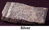
Silver:
Silver is a
white metallic element with atomic symbol Ag. It is highly lustrous and ductile.
Silver is used in a number of important industrial processes including
the manufacture of mirrors, jewelry and tableware.
Silver-Lead-Zinc Veins:
Idaho silver deposits are found in the Silver Valley near Kellogg along
the Coeur d'Alene River in north Idaho and near Hailey and Bellevue in south
central Idaho. These generally have supported the mining economy of Idaho
over the last 100 years, but their importance is decreasing. These veins are
formed when sulfide minerals fill void spaces in cracks or shear zones.
Coeur d'Alene District:
The Coeur d'Alene district in northern Idaho is one of the major lead-zinc-silver
producing areas of the world. Since mining began in the early 1880s, mines
in the 300-square-mile district have produced more than 2.89 billion dollars
worth of silver, lead, zinc, copper and gold.
The country rock (host rock) consists of six formations of the fine-grained,
siliceous, Precambrian Belt Supergroup. The sediments are intruded by several
types of small stocks and dikes. The structural geology of the area is complicated
by a variety of folds and faults of diverse acres and movements. The district
is at the intersection of the west-northwest-trending Osburn fault and a north-trending
anticlinal uplift. Six periods of mineralization ranging in age from Precambrian
to Tertiary have been identified. The main period of mineralization probably
occurred during the Late Cretaceous.
The productive veins, apparently controlled by deep fractures, trend northwesterly.
Although many veins crop out at the surface, some apex several thousand feet
below the surface. Depth appears to have had little effect on the occurrence
or type of ore.
DeLamar Silver Mine in Southwestern Idaho:
Gold was discovered in the DeLamar area in 1863; however, production,
primarily by underground mining, terminated in 1914. The exploration phase
for the DeLamar silver mine began in 1969 and by 1977 open pit mining was
started.
In 1986, ore reserves totaled approximately 11 million tons, averaging 1.8
ounces per ton of silver (and 0.023 ounces per ton of gold). Approximately
27,000 tons of ore and waste are moved each day, of which 3,300 tons are ore.
Current production includes about 1.6 million ounces of silver and 29,000
ounces of gold annually.
Silver and gold mineralization occurs in Tertiary silicic volcanic rocks at
the DeLamar Silver Mine. The silicic volcanics and subsequent mineralization
were controlled by large normal faults. Ore-grade mineralization is best developed
in porphyritic rhyolite domes overlying basalt flows.
 |
| Look at a picture from Lava Hot Springs. |
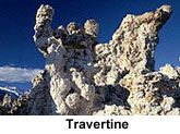
Travertine:
Travertine is a type of rock composed of mounds of calcium carbonate. It is
primarily formed from calcite (calcium carbonate) or aragonite deposition.
Travertine is most commonly seen near hot springs containing calcium rich
waters. The hot water bubbling up to the surface of the earth where it cools
down. As it cools the capacity of the water to hold calcium is reduced. The
calcium compounds deposit out of solution as solids, forming the travertine
mounds.
Travertine is sometimes used as an ornamental stone. It is polished as a type
of marble, and used for building.
Zinc:
Zinc is a metallic
element with atomic symbol Zn. The metal is used in the manufacture of galvanized
iron and other alloys. Zinc is also an important part of voltaic cells.
Silver-Lead-Zinc Veins:
Idaho zinc deposits are found in the Silver Valley near Kellogg along
the Coeur d'Alene River in north Idaho and near Hailey and Bellevue in south
central Idaho. These generally have supported the mining economy of Idaho
over the last 100 years, but their importance is decreasing. These veins are
formed when sulfide minerals fill void spaces in cracks or shear zones.
Coeur d'Alene District:
The Coeur d'Alene district in northern Idaho is one of the major lead-zinc-silver
producing areas of the world. Since mining began in the early 1880s, mines
in the 300-square-mile district have produced more than 2.89 billion dollars
worth of silver, lead, zinc, copper and gold.
The country rock (host rock) consists of six formations of the fine-grained,
siliceous, Precambrian Belt Supergroup. The sediments are intruded by several
types of small stocks and dikes. The structural geology of the area is complicated
by a variety of folds and faults of diverse acres and movements. The district
is at the intersection of the west-northwest-trending Osburn fault and a north-trending
anticlinal uplift. Six periods of mineralization ranging in age from Precambrian
to Tertiary have been identified. The main period of mineralization probably
occurred during the Late Cretaceous.
The productive veins, apparently controlled by deep fractures, trend northwesterly.
Although many veins crop out at the surface, some apex several thousand feet
below the surface. Depth appears to have had little effect on the occurrence
or type of ore.
Source Information