Cobalt: Cobalt is a silver-white metallic element with atomic symbol Co. Oxides of cobalt tend to be strongly colored - deep blues and greens being the most common. As such, these compounds have long been used for art pigments and dyes.
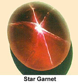 Star
Garnet: ‡Garnets
belong to a group of hard, vitreous minerals that are composed of silicates
of magnesium, calcium or iron. Alternatively they can be composed of manganese
with aluminum or iron.
Star
Garnet: ‡Garnets
belong to a group of hard, vitreous minerals that are composed of silicates
of magnesium, calcium or iron. Alternatively they can be composed of manganese
with aluminum or iron.
They vary across a wide color spectrum, with their dominant color determined
by mineral composition.
Clear red garnets are valued as jewelry. In addition, they are useful as industrial
abrasives.
Six-ray star garnets can be found in only two places in the world - Idaho
and India. Seeming to float just below the surface of the stones, the stars
appear magically when the stone is held in sunlight. These stars (the more
valuable garnets have stars with six arms, but some garnets have stars with
four arms) are caused by a residue of titanium dioxide trapped in the garnet
crystal. The result is so beautiful that this stone has been named Idaho's
state gem.
Raw garnets - both intact twelve-sided crystals up to two inches in diameter
and broken pieces - are found in streambeds in the Emerald Creek area near
Fernwood. The gemstones are not on the surface, but mixed with the sand, rocks,
roots, and dirt between the stream and the bedrock several feet below. Separating
the gems from the surrounding soil is a difficult and dirty job, but one that
draws thousands of visitors every summer to the digging area managed by the
Forest Service.
 |
 |
 |
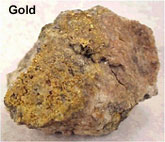
Much interesting human history has been created during the search for gold and associated riches. Gold was first discovered in Idaho in the Clearwater Country in 1860 by Captain Elias D. Pierce. Only a small amount was found (the monetary equivalent of about 3 cents) but it was enough to start the Idaho Gold Rush.
The Gold Rush lasted into the early 1900s and moved from one end of the state to the other as gold was discovered in new locations. People of all nationalities (Chinese, Welsh, Irish, Scandinavian and more) immigrated to Idaho to seek their fortunes. Although some few did "strike it rich" most did not.
Eventually "gold fever" subsided. However a number of productive gold mines continue to operate in Idaho today, and exploration for new deposits is an ongoing process.
Disseminated Gold Deposits:
Much of the recent exploration in Idaho has been for very fine grained gold disseminated in volcanic or sedimentary country rock. Sometimes there are also veins, but more often the gold is deposited as tiny particles in a dark-colored or altered host rock. Generally these deposits have formed where hydrothermal cells generated by magmatic activity have transported dissolved gold in ground water. The gold is deposited in the country rock where the temperature falls or the pH of the water rises. Usually these deposits are mined by open pit methods. Examples include the Black Pine deposit south of Burley, the Beartrack and Grouse Creek projects between Salmon and Stanley, and the Delamar project in extreme southwest Idaho.
Copper-Gold Skarn:
A skarn is a high temperature contact metamorphic deposit formed where a granitic pluton intrudes a limestone. The Cambior Exploration company in Mackay is exploring the old Empire mine property where skarn mineralization is present. Old mining activity in this district focused on veins of Copper, Silver, Zinc and Lead.
Placer Mines:
The mining of stream gravels which may contain concentrations of heavy minerals, especially gold, has been important in several places, notably Caribou Mountain, Placerville on the South Fork of the Boise, and the Yankee Fork of the Salmon River. This method of mining is detrimental to stream water quality. Only recreational placer mining occurs now. There is a large resource of very fine-grained placer gold on the Snake River on the Fort Hall Indian Reservation, but the technology of mining such fine grained gold has not been developed and also the potential for environmental damage is significant.
Lead:
Lead is a heavy,
bluish-gray metallic element with atomic symbol Pb. The metal is relatively
soft and malleable. It typically occurs in nature as sulfides (such as Galena),
and is often associated with silver and zinc.
Silver-Lead-Zinc Veins:
These deposits are found in the Silver Valley near Kellogg along the Coeur
d'Alene River in north Idaho and near Hailey and Bellevue in south central
Idaho. These generally have supported the mining economy of Idaho over the
last 100 years, but their importance is decreasing. These veins are formed
when sulfide minerals fill void spaces in cracks or shear zones.
Coeur d'Alene District:
The Coeur d'Alene district in northern Idaho is one of the major lead-zinc-silver
producing areas of the world. Since mining began in the early 1880s, mines
in the 300-square-mile district have produced more than 2.89 billion dollars
worth of silver, lead, zinc, copper and gold.
The country rock (host rock) consists of six formations of the fine-grained,
siliceous, Precambrian Belt Supergroup. The sediments are intruded by several
types of small stocks and dikes. The structural geology of the area is complicated
by a variety of folds and faults of diverse acres and movements. The district
is at the intersection of the west-northwest-trending Osburn fault and a north-trending
anticlinal uplift.
Six periods of mineralization ranging in age from Precambrian to Tertiary
have been identified. The main period of mineralization probably occurred
during the Late Cretaceous.
 The
productive veins, apparently controlled by deep fractures, trend northwesterly.
Although many veins crop out at the surface, some apex several thousand feet
below the surface. Depth appears to have had little effect on the occurrence
or type of ore.
The
productive veins, apparently controlled by deep fractures, trend northwesterly.
Although many veins crop out at the surface, some apex several thousand feet
below the surface. Depth appears to have had little effect on the occurrence
or type of ore.
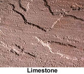
Limestone: Limestone is a soft, sedimentary rock primarily composed of calcium carbonate deposits. Limestone has the general chemical formula of CaCO3.
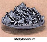
Molybdenum:
Molybdenum
is a silver-white metallic element with atomic symbol Mo. Although the most
important use of molybdenum is as an alloy to enhance the strength and durability
of steel, it has many other uses.
Molybdenum Veins:
Commercially useful molybdenum
is found in one location in Idaho. The Thompson Creek molybdenum mine, owned
by Cyprus Mining Company, between Challis and Salmon is located in altered
Cretaceous granitic rock. The mine is an open pit and produces from a stockwork
of tiny veins on the edge of a granitic body dated at about 87 Ma.
 Exploration
of the mine began in 1967 and continued for 14 years. In 1978 the decision
was made to develop the property. The ore body consists of an igneous granitic
stock of Late Cretaceous age intruded argillites of Mississippian age. The
intrusive and sedimentary rocks are overlain by Challis volcanics of Eocene
age. The molybdenite occurs primarily veins and veinlets disseminated throughout
the deposit.
Exploration
of the mine began in 1967 and continued for 14 years. In 1978 the decision
was made to develop the property. The ore body consists of an igneous granitic
stock of Late Cretaceous age intruded argillites of Mississippian age. The
intrusive and sedimentary rocks are overlain by Challis volcanics of Eocene
age. The molybdenite occurs primarily veins and veinlets disseminated throughout
the deposit.
The ore body has
an estimated 181 million tons of reserves, averaging 0.18 percent molybdenite.
Actual mining and ore processing began in 1983, more than 17 years after Cyprus
staked its claims. This mine, with associated facilities and equipment, is
one of the most modern large open pit mines in the western United States.
Phosphate:
†Phosphorus
is a solid, nonmetallic element with atomic symbol P. It can exist in two
forms - one yellow, poisonous and highly flammable, the other is red, less
poisonous and less flammable. An interesting property is that water does not
put phosphorus fires out, the element will continue to burn under water. Phosphorus
is an extremely useful element and is of great commercial importance. Production
of the element and byproducts (such as fertilizer) contributes significantly
to Idaho's economy.
The southeast Idaho phosphate industry produces the greatest amount of income
to the state of any precious mineral. The deposits are found in the Permian
Phosphoria Formation and are mined by open pit methods. These are stratigraphically
controlled concentrations of P205. Concentrations of about 15 to 30% are minable.
Southeastern Idaho contains both the thickest and richest phosphate deposits
in the western United States. Idaho phosphate accounts for as much as 14 percent
of the total phosphate produced in the United States, and is second only to
phosphate production in Florida and North Carolina. Phosphate is of economic
interest primarily for production of fertilizer and a myriad of products from
detergents to soft drinks.
The geology of southeastern Idaho was first studied by members of the 1877
Hayden Survey, They recognized some of the broad structural features and the
Carboniferous and Triassic rocks in the area however, the Permian phosphate
deposits were not discovered until 1889 by Albert Richter. Since that time
| Click here to look at a distribution map of the Phosphoria Formation. |
geologic efforts have
focused on the area's vast phosphate resources and secondarily as a possible
source of vanadium and uranium.
Phosphoria Formation:
The Idaho phosphate deposits are sedimentary rocks that occur in the Permian
Phosphoria Formation. The Phosphoria Formation is centered in Idaho, but extends
regionally into northeastern Nevada, northern Utah, western Wyoming, and southwestern
Montana.
In southeastern Idaho, the Phosphoria is subdivided into three members, in
ascending order: the Meade Peak Phosphatic Shale Member, the Rex Chert Member,
and the cherty shale member.
The rich phosphate beds occur in the Meade Peak Phosphatic Shale which reaches
a maximum thickness of about 230 feet in southeastern Idaho. Since the Meade
Peak is a relatively soft lithologic unit, it is rarely exposed, but is recognized
at the surface by the presence of adjacent erosion resistant units. The region
is structurally complex and strongly folded so the bedding of the Meade Peak
is commonly tilted to steep angles. Because of differential erosion and the
tilting, the Meade Peak is characterized by a dominant surface swale that
occurs parallel to the strike of the bedding.
Phosphate occurs in the Meade Peak in sedimentary rocks called phosphorite
and phosphatic mudstone.
Phosphorites are composed dominantly of phosphate minerals, varieties of the
mineral apatite, that occur in tiny spherical particles called ooliths and
peloids (less than 2 mm in diameter) and in larger nodules and fossil fragments.
Ooliths, the most abundant of the smaller particles, are accretionary particles
composed of concentric bands around a nucleus. Individual phosphatic particles
are hard and nearly black. Weathering of phosphate-rich rocks produces a bluish-white
coating referred to as "phosphate bloom" which aids in recognition
of phosphate in surface samples.
Deposition in a Shallow Sea:
The Phosphoria Formation was deposited in a shallow sea during the Permian
Period. While phosphate-rich water may have originated and upwelled from deeper
ocean waters, phosphate-rich sediment accumulated, was reworked and deposited
as sediment in the relatively shallow waters of an epicontinental seaway or
embayment. Some phosphate deposition is also thought to have occurred as a
result of diagenetic processes, that is, formed by precipitation of apatite
within intergranular spaces and pore water after initial deposition of sediments.
The formation and concentration of spherical peloids and oolites, as described
above, required agitation by wave action and winnowing of sediment that would
occur in a shallow-ocean environment in times of maximum regression of the
sea.
Structural Setting:
The geometry of the southeastern Idaho phosphate deposits is attributable
to the complex structural geologic setting of the region. Most of the structural
deformation of the region is the result of major episodes of tectonic activity
occurring in the Mesozoic and Cenozoic eras. Southeastern Idaho is part of
the Idaho-Wyoming thrust belt where regional compression from Late Jurassic
to Cretaceous time resulted in substantial crustal shortening. This crustal
shortening, achieved by thrust faulting and folding, is responsible for the
effective doubling of the overall stratigraphic thickness. In Tertiary time,
regional extension of the Basin-and-Range Province produced north- to northwest-trending
normal faulting in southeastern Idaho. Recent seismic activity indicates that
Basin-and-Range-type deformation continues to the present. As a result of
the overprinting of these structural events, the Phosphoria Formation and
associated stratigraphic units are folded, faulted, and tilted.
Mining of Phosphate:
In southeastern Idaho,
phosphate is mined in large open-pit mines. Because the phosphate beds are
tilted and oriented along large folds, open-pit mines in southeastern Idaho
are long, linear trenches excavated along strike of the bedding. Phosphate
rock is mined downward along the dip of bedding to an economic depth (currently
as much as 300 feet or more). The economic viability of a particular phosphate
deposit is related to many factors including the thickness and grade (P2O5
content) of the rock, the amount of overburden that needs to be stripped off
to reach the phosphate beds, location, market considerations, and structural
geologic complications. The depth to which the phosphate is weathered is also
a critical factor. The more weathered the phosphate is generally the richer
the ore and the more easily mined. Phosphate ore is mined using large mine
shovels and scrapers and is transported by ore truck, rail line, or slurry
pipeline to processing plants in Soda Springs, Pocatello, and other locations
in the region.
Processing of Phosphate
Ore:
Phosphate rock
in southeastern Idaho is either: 1) processed into chemical fertilizer products
by a wet process that dissolves phosphate rock with sulfuric acid to produce
phosphoric acid; or 2) processed into elemental phosphorus by smelting a mixture
of agglomerated phosphate rock, silica, and fine-free coke in a submerged-arc
electric furnace. Phosphate rock in the western phosphate field is generally
classified as followed:
* High grade (or
acid grade) is plus 31% P2O5
* Medium grade (or furnace grade) is 24 to 31% P205
* Low grade (or beneficiation grade) is between 16 and 24%P2O5
High-grade rock is used
directly in fertilizer plants- medium-grade rock can be used directly in the
elemental plants; and low-grade rock needs to be upgraded (beneficiated) to
furnace or acid grade.
Potential Byproducts
of Phosphate Production:
Phosphatic units of the
Phosphoria Formation are enriched in many rare elements; however, only vanadium
is currently being recovered as a byproduct of elemental phosphate production
in the western phosphate field. Vanadium is used as an alloying element in
steel to improve its strength, toughness, and ductility. Other elements with
potential as byproducts are uranium, fluorine, rare earth elements, silver,
cadmium, chromium, molybdenum, arsenic, selenium, strontium, tellurium, and
zinc. Some elements such as fluorine, uranium and its decay products, cadmium,
thallium, and mercury should be recovered to avoid environmental risks from
phosphate products or waste materials from phosphate processing.
Reclamation of Mined Lands:
While open-pit mining of phosphate has definite impacts on the natural
environment, substantial progress has been made in southeastern Idaho to mitigate
impacts and reclaim surface disturbance through the cooperative efforts of
phosphate companies with Federal and state agencies. Land reclamation is the
process of returning land disturbed by mining to productive uses. Specifics
of the mine operation dictate the type and timing of the reclamation done.
Reclamation of the surface disturbed by mining includes the regrading of waste
dumps and mine cuts to stable gradients and the establishment of vegetation.
The establishment of the suitable vegetative cover aids in improving the soil,
protecting the land surface from erosion, improving aesthetic values, and
in restoring the land to productive uses such as grazing and production of
crops.
Future of Idaho
Phosphate:
As in the past,
the future of the Idaho phosphate industry will depend on the market demands
for phosphate fertilizer and chemical products which is strongly influenced
by fluctuations in the agriculture and consumer industries.
Source Information
‡For more information about garnets contact: U.S. Forest Service, St. Maries Ranger District, P.O. Box 407, St. Maries, ID 83861, 208-245-2531.
†Phosphate information by, R. David Hovland, Geologist and Steven W. Moore, Geologist