![]()
 |
Explore Craters * Contacts * FAQ * Tour * Trails |
|
|
||
|
||
|
|
||
Established in 1924
Visit Craters of the Moon Monument Web Site
Craters of the Moon National Monument, established in 1924, is the result of basaltic volcanic activity between 15,000 and 2,100 years ago.
Topography
Craters of the Moon lies at the north edge of the eastern Snake River Plain. There are two distinct landforms in the monument: the foothills of the Pioneer Mountains in the north give way to the low relief of the lava flows in the rest of the monument. The monument's highest elevation is in the Pioneer Mountains, 7,729 feet above sea level. The lowest elevation is about 5,330 feet located in the southeast corner of the monument. Elevations gradually decrease from north to south. Within the lava flows, cinder cones provide the greatest vertical relief. The highest cinder cone is Big Cinder Butte which stands more than 700 feet above the surrounding plain. Nineteen other cinder cones are at least 100 feet high. The Great Rift is apparent from the linear alignment of the cinder cone.
Volcanic Features
The primary resource value of Craters of the Moon is the great diversity of basaltic features in a small area. Almost all the features of basaltic volcanism are visible at the monument.
Much of the volcanism of the Snake River Plain was confined to volcanic rift zones. A volcanic rift zone is a concentration of volcanic landforms and structures along a linear zone of cracks in the earth's crust. The Great Rift volcanic rift zone is a zone of cracks running approximately northwest to southeast across almost the entire eastern part of the Snake River Plain. The entire Great Rift is 62 miles long.
The Great Rift is an example of basaltic fissure eruption. This type of volcanic activity is characterized by extrusion of lavas from fissures or vents that is relatively quiet in comparison with highly explosive eruptions such as the 1980 Mount Saint Helens eruption.
Where the Great Rift intersects the earth's surface, there is an array of cinder cones, lava cones, eruptive fissures, fresh-appearing lava flows, noneruptive fissures, and shield volcanoes.
Of the more than 60 lava flows of the Craters of the Moon lava field, 20 have been dated: their ages were found to range from about 15,000 years before present to about 2,100 years before present. The flows were laid down in eight distinct eruptive periods that recurred on an average of every 2,000 years. On the basis of recent eruptive history, the Craters rift set is due for another eruption within the next thousand years, perhaps as soon as within 200 years.
Brief Chronology of Geologic Events at Craters of the Moon
1. Around 8 million years ago the Yellowstone Hot Spot was beneath Craters of the Moon (the caldera to the west is 10 million and the one to the east is 6 million). A time of violent rhyolitic eruptions.
2. Between 6 million and 15,000 years ago basaltic eruptions produce about a 4,000-ft. thickness of basalt flows (data from east of park).
3. Between 15,000 and 2,000 years ago the present day surface of the Craters of the Moon Lava Field forms during 8 major eruptive periods. During this time the Craters of the Moon Lava Field grows to cover 618 square miles.
4. Today the monument preserves and protects 83 square miles of the lava field for present and future generations to enjoy and learn from.
The Hot Spot
One explanation for the existence of the Snake River Plain and the Craters of the Moon lava field is called the mantle plume theory. This theory states that beneath the crust of the Snake River Plain lies a "hot spot" or localized heat source. Periodically, this hot spot consists of a "plume" of molten rock (magma) which rises buoyantly to the surface of the earth. The hot spot does not move but rather remains in a fixed position. What does move is the crust of the earth; as the North American plate slides southwestward over the hot spot. As the plate moves over the hot spot volcanic eruptions occur creating a string of volcanic acitvity on the surface.
Initially these eruptions are very violent and produce a lava known as rhyolite. Huge calderas of up to 30 miles in diameter are formed when these devastating eruptions take place. Later a more fluid lava known as basalt flows onto the surface and covers the rhyolitic flows. Yellowstone National Park, the area where the hot spot is believed to be located at this time, is the place where catastrophic rhyolitic eruptions last occurred 600,000 years ago. Craters of the Moon represents the second stage of the eruptions where fluid basaltic lava covered the landscape as recently as 2,000 years ago.
Geologic Description
The Craters of the Moon (COM) Lava Field is made up of about 60 lava flows and 25 cones. It is the largest and most complex of the late Pleistocene and Holocene basaltic lava fields of the Eastern Snake River Plain (ESRP). The lava flows here exhibit a wide range of chemical compositions. In the last 15,000 years there have been 8 major eruptive periods at COM. In contrast, most of the other lava fields in the ESRP represent just single eruptions, have about the same composition (olivine tholeiites, i.e. silica over-saturated basalt), and were widely scattered in space and time.
The COM lava field formed from magma (molten rock below the surface of the earth), which came up along the Great Rift. The Great Rift is a system of crustal fractures. It extends from the base of the Pioneer Mountains near the visitor center off to the SE for 62 miles. COM lava field is the northern most of 3 lava fields found along the Great Rift. The Great Rift and other volcanic rifts on the ESRP are generally parallel to but not collinear with Basin and Range faults north and south of the plain.
When magma comes to the surface along a segment of a rift, it often begins by producing a curtain of fire, a line of low eruptions. As portions of the segment become clogged the fountains become higher. If magma comes to the surface highly charged with gas it is like taking the cap off of a bottle of pop that has been shaken-- it sprays high in the air. The fire fountains that produced many of the COM cinder cones were probably over a 1,000-ft. high. Big Cinder Butte, the tallest cinder cone in COM, is over 700-ft. high. The highly gas-charged molten rock cools and solidifies during flight and rains down to form the cinder cones. If you look at cinders you will see that they are laced with gas holes and resemble a sponge or piece of Swiss cheese; all the gas holes make cinders very light in weight.
Molten rock on the surface it is called lava. Of the 60 lava flows visible on the surface today, 20 have been dated. The oldest is about 15,000 years old and the youngest about 2,000. The lava flows at COM have similar parent (olivine tholeiitic) magma to the rest of the plain, but are fractionated and exhibit chemical characteristics of crustal contamination. Some lava flows had a smooth, ropy, or billowy surface—pahoehoe lava. Others were very dense and had a surface of angular blocks—block lava, while still others had a rough, jagged, or clinkery surface—aa lava. There are also 3 special kinds of pahoehoe that can be seen in the COM lava field: 1) slab pahoehoe, also known as semihoe, which is made up of jumbled plates or slabs of broken pahoehoe crust, 2) shelly pahoehoe, which forms from gas-charged lava and has small open tubes, blisters, and thin crusts, and 3) spiny pahoehoe, which was very thick and pasty and a transition phase to aa, has stretched elongated gas bubbles on the surface that form spines.
Most of the COM lava flows are pahoehoe and were fed through tubes and tube systems, though there are some sheet flows. In COM structures representing both inflation and deflation of the lava surface can be seen along with hot and cold collapses of the roofs of lava tubes. Inside lava tubes you can see lava stalactites, remelt features, and lava curbs. In other places lava flows formed ponds, built levees, and produced lava cascades. Some lava flows produced small mounds (tumuli) or elongate ridges (pressure ridges) on their crusts.
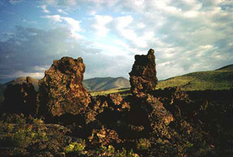
Some vents along the rift ejected very fluid particles (spatter) that accumulated to form steep sided spatter cones. Along eruptive fissures where a whole segment was erupting, spatter accumulated to produces low ridges called spatter ramparts. Similar in appearance to spatter cones are hornitos, also known as rootless vents. They formed from spatter that was ejected from holes in the crust of a lava tube instead of directly from a feeding fissure. COM also has rimless collapses known as sinks or pit craters. During some eruptions pieces of crater walls were carried off like icebergs by lava flows. These wall chunks are known as rafted blocks, the monoliths across from the visitor center are examples.
Monument History
The explorers, pioneers, miners, and ranchers, who traveled this area from the 1850s through the early part of this century, could find nothing to love about it. The parched and inhospitable lava beds were only an obstacle to get past as quickly as possible. All of that changed in 1918 when Robert W. Limbert, one of Idaho's most tireless and flamboyant promoters, began to explore Craters of the Moon. His curiosity piqued by stories of grizzly bears roaming the mysterious lava beds, he made two short trips into the area.
In the Spring of 1920 he was ready for a more daring undertaking. Accompanied by W.L. Cole of Boise, he completed a 17 day, 80 mile odyssey through the lava wilderness. They carried blankets, cooking gear, camera and tripod, binoculars, a compass, guns, and two weeks of dried food - 55 pounds of equipment each! They also brought along a camp dog, a decision they were to regret. After three days of travel over the rough lava, the dog's feet were raw and bleeding. For the remainder of the trip, Limbert and Cole had to carry the dog or wait for him to pick his way across the rock.
They crossed 28 miles of jagged aa flows the first three days. Sleeping at night was almost impossible, for they could not find a level place to lie down. To locate scattered waterholes, they followed old Indian or mountain sheep trails, or watched for places where groups of birds dropped from the sky to quench their thirst.
Throughout the trip Limbert photographed the landscape. He also gave colorful names to many features: Vermillion Canyon, Trench Mortar Flat, Echo Crater, Yellowjacket Water Hole, Amphitheater Cave, and the Bridge of Tears.
Limbert continued to explore the region following this journey. In 1921 he led 10 scientists and civic leaders into the lava fields and argued for protection of the area's volcanic features. During the trip he made over 200 still photographs and 4,000 feet of motion picture film.
Limber vividly described his experiences in a series of striking photo essays in newspapers and magazines. The most prominent was a 1924 National Geographic article entitled "Among the 'Craters of the Moon'." He wrote, "No more fitting tribute to the volcanic forces which built the great Snake River Valley could be paid than to make this region into a National Park." Limbert also sent President Calvin Coolidge a scrapbook with pictures and narration describing his trips along the Great Rift. Within two months after the article appeared, Coolidge issued a proclamation establishing Craters of the Moon National Monument. About 1,500 people traveled over the gravel and cinder roads to attend the dedication ceremony on June 15, 1924.
Limbert was the first person to recognize the potential of Craters of Moon to fascinate and delight visitors. He said, "Although almost totally unknown at present, this section is destined some day to attract tourists from all America, for its lava flows are as interesting as those of Vesuvius, Mauna Loa, or Kilauea." Although this prediction did not prove true in his lifetime, today more than 200,000 people visit Craters of the Moon National Monument each year.
Habitats
The barren, harsh lava flows of the monument often give the viewer the impression that this is a lifeless landscape. Even though animal populations may be relatively low on the lava itself, there are numerous hospitable habitats available here as well. Four of the most common habitats are:
1. Lava Flows
2. Cinder Areas
4. Kipukas
Older flows and cinder fields support a variety of different plant communities ranging from wildflower gardens, to sagebrush steppes, to dense forests. The different characteristics of the lava deposited here also provide varied environments of bare rock, deep cracks, jagged piles, cinder flats, and underground caves that support an equally varied group of wildlife species. The periodic eruption of lava created a mosaic of plant communities, all at different stages of succession with widely different plant and wildlife species.
Vegetation and Wildlife
Twenty-six distinct vegetation types have been described within Craters of the Moon (Day, 1985).
This unique mixture of habitats and differing vegetation supports a very diverse population of animals. A total of nearly 168 bird, 46 mammal, 8 reptiles, and 2 amphibian species have been reported in Crater of the Moon. Five of the animal species — grizzly bear, gray wolf, bison, porcupine, and bighorn sheep — are known to have been eliminated from the monument. For the most part, the animals found at the monument are those most common to the sagebrush steppe habitat of the intermountain west. Some of the common species seen at the Monument include:
1. Fox
2. Marmot
3. Mule Deer
In addition, three subspecies of unique small mammals endemic to the Snake River Plain were first identified in Craters of the Moon. A subspecies of the Great Basin pocket mouse was first taken from Echo Crater, as was the first specimen of a race of the pika. As might be expected for mammals that live on lava flows, both races are characterized by darker fur than other races of the species. The first specimen of a subspecies of the yellow-pine chipmunk came from Grassy Cone.
Supplemental Material
Rocks, Rails & Trails: pp. 3, 21-22 and 147-149
The field guides below are a part of the Guidebook to the Geology of Eastern Idaho :
Also Visit