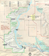
 Use
the GIS maps above to explore information about Hagerman Fossil Beds.
 Hagerman Fossil Beds Elevation
Map
Hagerman Fossil Beds Geologic
Map
Hagerman Fossil Beds Soil
Type Map
Hagerman Fossil Beds Vegatation
Map
Return to Hagerman Fossil Beds
 Use
the GIS maps above to explore information about Hagerman Fossil Beds.
Get started by orienting yourself to the area being covered, Click here to look at a Map of the Park.
ALSO Look at view of the Hagerman Hills, looking south west.
Click here to look at a set of
Hagerman data tables. This is a Microsoft Access file, Click
here for more information.
Go visit the Map Archives for access to additional Hagerman GIS data.