|
Page
40
|
The Louisiana Purchase
After a long
period of secret treaties between Spain and France over the area vaguely referred
to as "Louisiana," Spain returned control of the area to France by
the secret treaty of San Ildefonso on October 1, 1800, although possession was
not transferred until late 1802. Shortly thereafter, Napoleon Bonaparte, who
needed money to finance his English wars, offered to sell the area to the United
States. Napoleon feared that conflict with Great Britain would result in the
loss of "Louisiana" without benefit to France. President Jefferson
promptly accepted the offer, and in 1803, the Louisiana Purchase was made.
The boundaries of the area involved in the Louisiana Purchase were uncertain. It took a number of agreements over a period of years to establish the limits. Roughly, the Purchase involved the area drained by the Missouri and Mississippi Rivers, with the eastern boundary being the Mississippi River and the western boundary being the Continental Divide, excluding Texas. While none of the area of the Pacific Northwest was included, the Louisiana Purchase encouraged interest in and ultimately movement into the Northwest by both the United States and Great Britain.
The location of the boundary between the United States and Canada remained uncertain for many years. East of the Continental Divide, an international boundary at the 49th Parallel was settled in 1818 by the Treaty of Ghent, ending the War of 1812. The status of the Northwest area, west of the Divide, remained in dispute. The Treaty established the area as far north as Russia, at 54° 40' (the present southern boundary of Alaska at Juneau), as neutral ground, open to the citizens of both countries for a period of 10 years, at which time the matter of its ownership was to be taken up again. Russia's interest in the Northwest area was abandoned by 1812 when it devoted its efforts on the Pacific Coast to building posts in California in the vicinity of San Francisco.
Spain's interest in the area north of the 42nd Parallel was eliminated by the Adams-Onis Treaty of 1819 settling claims of the United States to Florida and areas in western North America. This was the origin of the arbitrary southern boundary of what was to become Idaho territory.
Commercial exploitation of the Northwest had not waited for the politicians to decide whose country owned what. Under the excuse of discovering what manner of territory the United States had acquired from France, Jefferson sent an expedition, under the joint command of Meriwether Lewis and William Clark, to the western border of the Louisiana Purchase. Secret orders were for the party to continue on to the Pacific Ocean.
Lewis
and Clark
In 1804 the Lewis
and Clark expedition set out, reaching the Pacific at the mouth of the Columbia
River in late 1805. The report of this party together with the information from
Alexander Mackenzie following his 1793 journey excited fur trapping
interests in both countries and soon the area swarmed with trappers. This opened
a 30 year period of competition and conflict. The disputes were finally settled
in 1846 when the northern border between the United States and Canada was established
by extending the line along the 49th Parallel to Puget Sound.
 |
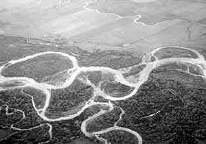
| Aerial view looking southeast across the Snake River and the Fort Hall Bottoms, above the site of Old Fort Hall. Spring Creek meanders across the farmland in the upper part of the photo, (May, 1989). |
The
North West Company
Trappers ranged
over the broad area of the Northwest beginning in 1807 with a party from the
British commercial North West Company under the leadership of David Thompson.
In 1808 Thompson established a trading post in what was to become northern Idaho,
where the Clark Fork River enters Lake Pend Oreille, and named it Kullyspell
House. American trappers of Manuel Lisa's Missouri Fur Company, meanwhile, were
working the upper Missouri River area. A small party under Andrew Henry, escaping
from the fierce Blackfeet Indians in the Three Forks area (now southern Montana),
moved over the mountains into today's Idaho and, in the fall of 1809 built a
wintering post on the Henry's Fork of the Snake River near present day St. Anthony,
known ever since as Fort Henry.
The
Astorians
The entrepreneur
and aggressive American fur merchant John Jacob Astor, in 1811, sent two expeditions
to establish a permanent post in the Northwest. One party moved by sea in the
good ship Tonquin, to the mouth of the Columbia River and built Fort Astoria.
The second expedition was an overland party, under the direction of Wilson Price
Hunt, that traveled through southern Idaho, reaching Astoria in 1812. The Hunt
Party was the first American group to explore the Snake River.
Astor's venture failed when British interests acquired Fort Astoria under the threat of capture by naval units during the War of 1812. Thereafter, most of the fur trapping and trading west of the Rocky Mountains was handled by British interests, first by the North West Company; and after the 1821 merger with Hudson's Bay Company, by that company until the 1850s.
Overtrapping
to make a Barren Zone
The trappers of
both countries ranged throughout the Northwest. Concern over intrusions by American
trappers prompted Hudson's Bay Company to depart from its usual emphasis on
conservation and to embark on a plan to establish a barren zone along the Snake
River in eastern Idaho by trapping out all fur bearing animals. The policy was
pursued vigorously in the 1820s by British explorer-trapper Peter Skene Ogden.
It largely succeeded in reducing the supply of available pelts until well into
the 1830s.