|
Page
44
|
Salt
Lake Cutoff
As the Latter-Day
Saint towns in the Salt Lake Valley grew in the 1850s, increasing numbers of
wagons followed the Mormon Trail west from Fort Bridger to the Salt Lake Valley
and rejoined the California Trail southwest of the Silent City of Rocks. After
that point was reached, all travelers to California used a single route, crossing
Granite Pass in southern Idaho to reach the Humboldt River in northern Nevada.
They then followed it to the Sierra Nevada. Most Oregon-bound pioneers took
the main road past Fort Hall.
 |
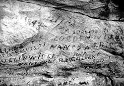
| Writing by pioneers at Register Rock along the Oregon Trail in the Silent City of Rocks, (September, 1987). |
Fort
Hall and West
Hudson's Bay supplies
were expensive and many travelers could not afford them. Fort Hall was abandoned
in 1856, without appreciable effect on the trail. Even when it was open, there
was little reason for most pioneers to stop at the Fort. Staying on the southeast
side of Spring Creek avoided a difficult stream crossing, so it seems logical
that the main trail bypassed Fort Hall. Accounts are not very clear, but the
ruts which are at the Fort do not seem to reflect travel by over 50,000 pioneers
and their wagons.
South of Fort Hall the Trail headed southwest along Spring Creek to a crossing of the Portneuf River. The most-used trail followed the south side of the Snake River to the often difficult and dangerous Three Island Ford near present day Glenns Ferry, crossing to the north side and on to the Boise River Valley. An alternate route, which was drier and longer, stayed on the south side of the Snake to the mouth of the Boise River. Here the north-side travelers recrossed the Snake and a single route headed northwesterly through Oregon to The Dalles, where travelers could go down the Columbia by boat to the terminus of the Oregon Trail at Oregon City on the Willamette River south of Portland, or could use the Barlow Trail around Mt. Hood and on to the terminus.
Goodale
Cutoff
There were several
branches and cutoffs in Idaho. In the vicinity of Fort Hall, a somewhat difficult
route headed north across the Snake River Plain and along the south side of
the mountains of central Idaho to a junction with the main trail near present
day Mountain Home. This was the Goodale or Jeffrey's Cutoff, which was opened
as an emigrant route by John T. Jeffrey in 1852 or 1854. Timothy Goodale led
a wagon train consisting of 1,095 people over the route in late summer, 1862.
These emigrants and most who subsequently traveled the cut off, were miners
and their families seeking gold in central or western Idaho.
 |
 |
|
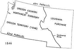
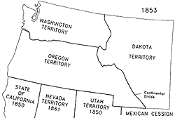
Territorial
divisions before and after the Mexican War (1848), after Beck and Haase
(1989, Map 41).
|
|
Northside
Route
Although most
travelers crossed to the north side of the Snake River at Three Island Ford,
it has been suggested by some that there was a trail along the north side of
the Snake River all the way from Fort Hall. A total absence of surface water
on the north side of the Snake River plus the lack of access for animals over
the lava cliffs to the Snake River below would seem to preclude much use of
a northside route.
Applegate
Route
Some Oregon-bound
travelers after 1846 followed the California Trail to western Nevada and then
up into Oregon and the upper reaches of the Willamette River, along what was
known as the Applegate Route. This longer, drier and much more dangerous route
was not heavily used.
End
of the Trail
The stream of families
moving west by wagon continued at a reduced rate into the 20th Century. One
could not, after all, easily ship one's total belongings and farm animals by
train. It is said that use of the Oregon Trail came to an end not because of
the railroads, but because of the automobile.
Wagon
Ruts
There are many areas in
southern Idaho where wagon ruts of the various routes can be seen. A few traces
of the trails are clearly visible, but in most areas, farming activities or
roads or civilization have obliterated the ruts. Very often the route of the
trail can still be discerned, even in areas where the actual ruts are not visible,
by a more luxuriant growth of grasses or sagebrush where the droppings of millions
of animals fertilized the soil. Often the wagon route can be more easily observed
from the air than on the ground.