|
Page
97
|
|
||
|
||
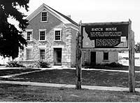
| Home of L.H. Hatch in Franklin, built 1874. Hatch was a prominent Mormon bishop, polygamist, and political leader. House stands next to the ZCMI Co-op, (June, 1992). | ||
|
||
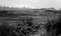
| Utah & Northern Railway grade just north of Preston.The grade is the raised embankment dotted with sagebrush in the foreground. View looks west across the Bear River toward the south end of the Bannock Range near Dayton, Clifton and Oxford, (April, 1996). | ||
|
||
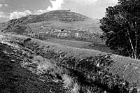
| Raised roadbed of Utah-Northern Railroad at Johnson Reservoir north of Preston. Rails were never laid. The route was rejected after the reorganization of the Utah & Northern Railway in favor of a route across the Bear River and up Battle Creek, (august, 1992). | ||
|
||
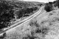
| Site of Utah & Northern Railway grade climbing up Battle Creek north of the Bear River in Cache Valley. The narrow gauge grade followed the steep unimproved road in the foreground, (august, 1992). |
Franklin
Franklin
was the first settlement in Idaho, established by Mormon Pioneers in 1860. Clifton,
Weston, and Dayton were established in 1864, 1865, and1867.
Lorenzo Hill Hatch was Bishop of Franklin from 1863 to 1875. His son was bishop from 1875 to 1907. He came west with the 1846 migration from Nauvoo, Illinois. Hatch married plural wives and was the father of twelve sons and twelve daughters. At the time of his death in 1900 he had 170 grandchildren and 32 great grandchildren.
Utah-Northern
Railroad
The Utah-Northern
Railroad Company, a cooperative project of the Mormon Church and local farmers,
reached Franklin in 1874 and the Bear River at Battle Creek in 1876, but the
company ran out of money. Utah-Northern shops had been built at Battle Creek,
just south of the Bear River, at the site of Connor's Massacre.
The roadbed for the Utah-Northern Railroad, headed north to Soda Springs, was built toward Riverdale and Oneida Narrows, but tracks were never laid. It is still plainly visible near Johnson Reservoir north of Preston.
When construction was begun again (by the reorganized Utah & Northern Railway), the route headed north through Red Rock Pass to Marsh Valley and Pocatello.
Preston
Preston
(originally called "Worm Creek' when it was founded in 1874), was located
where it is because ground water, though alkaline, was shallow on the west banks
of Worm Creek. In 1880, the name Worm Creek was changed to Preston, honoring
Bishop Wm. B. Preston of Logan. Mormon leaders had, thankfully, objected to
the word "worm." In 1881, the Cub River and Worm Creek irrigation
system began. It was the first of several canal systems that would bring water
to Cache Valley. In 1888, the townsite of Preston was surveyed and platted.
Nellie Parkinson, whose husband was the bishop of the Preston ward, describes
conditions in 1884:
|
In 1890, the Oregon Short Line & Utah & Northern Railway laid standard gauge railroad tracks to replace the old narrow gauge line, and the main line was moved to the west side of the valley. Preston became the terminus of the branch line from Logan.
The first water system for Preston was in 1912, to replace the alkaline wells. In 1913 Oneida County was divided; Preston became the county seat of Franklin County.
In 1914, a building boom began. Many of the brick buildings of downtown date from this era. The demand during World War I for agricultural products brought a real time of prosperity to Cache Valley from 1915 to 1921. The1920 population of Preston was 3,235, approximately the same as 1970, and only 500 less than 1990.