|
Page
98
|

|
||
|
||
| Schematic view showing geologic setting of Bear River Landslide Complex, from Link and others (1987). Click on image for a larger view. |
West
Cache and Twin Lakes Canals
In 1899,
the West Cache Canal, designed to water 17,200 acres on the west side of Bear
River, was begun. The Twin Lakes Canal was begun in 1902 by enthusiastic farmers
who were advised that the project would take 5 years and cost $282,000. Instead
it took 20 years and cost $1,500,000.
Hot
Springs
Natural
hot springs exist along the Bear River at several locations north and west of
Preston. The water is emitted along the trace of the normal fault which bounds
the east side of Clifton Hill or Little Mountain east of Twin Lakes Reservoir.
Commercial hot springs were operated at Old Bridge Porte just south of Battle
Creek and at Riverview Sunset Del Rio Hot Springs half a mile downstream. Presently
a hot springs complex at Riverdale is operated as a swimming pool.
 |
 |
 |
|
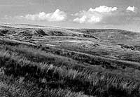
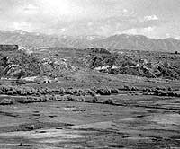
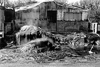
(left) Headwall scarp of "Highway slide" which cuts the old alignment of U.S. Highway 91 north of the Bear River and Preston, (august, 1983). (center) Wide canyon of Bear River, looking east from the old grade of Highway 91, cut in unconsolidated sands and silts deposited in Lake Bonneville.The landslide shown in the upper photo on p. 99 is directly across the tree-lined course of the Bear River. Bear River Range in the background,(June, 1992). (right) Squaw Hot Springs building west of Preston. Building was vacant at the time of this photograph (June, 1992). It had been used in the past ten years as a greenhouse and a pig farm. Large travertine-coated open well flows water at 84° centigrade. |
||
Bear
River Landslide Complex
Active
rotational landslides exist on both banks of the Bear River north and west of
Preston. These landslides represent response of unconsolidated Lake Bonneville
silts, sands, and clays to the lowering of the base level of the Bear River
after the drying up of the remnants of Lake Bonneville about 14,000 years ago.
Installation of irrigation systems in the country both east and west of the
river resulted in major landslides in the 1910s. Wet cycles of several years
of duration with higher than normal rainfall have triggered periods of landsliding
since then. The last period of active earth movement was in 1983-86. In 1993,
the grade of U.S. Highway 91 was reconstructed to the west, away from the face
of the hill, to avoid its former grade over a headwall scarp of one of these
landslides.