|
Page
99
|
|
||
|
||
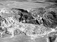
| Scar of landslide along the south bank of the Bear River. Photo taken in May, 1983. Trace of old farm road can be seen across the earthflow. Arcuate scars of former landslides can be seen to the right of the active flow. | ||
|
||
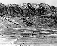
| Oxford Mountain and Oxford Basin looking west from central Cache Valley near the railroad siding at Oxford. The Lake Bonneville shoreline forms the straight bench (lBS). The dark cliffs behind Oxford basin are underlain by Late Proterozoic rocks of the Pocatello Formation. The rocks at the top of the mountain belong to the Brigham Group, and dip eastward above a flat younger-over-older fault, (October, 1978). | ||
|
||
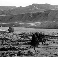
| Late spring (1992) afternoon south of Red Rock Pass. The prominent bench in the background is the alluvial fan surface incised by the Lake Bonneville Flood. Uneven country just across the railroad track is scab land where bedrock was scoured and jostled by the flood. |
Oxford
Oxford
was settled in 1864. With completion of the Utah & Northern, the town became
a mixed Mormon-Gentile community and aspired to replace Malad City as county
seat of Oneida County. Oxford obtained the public land office in 1879 and a
newspaper, the Idaho Enterprise, in 1880. Oscar Sonnenkalb lived there from
1881 to 1889.
Oneida County, in the 1880s, embraced 13 of the present counties of southeastern Idaho, extending 180 miles south to north from the Utah border to Montana, and about 100 miles east to west from the Wyoming border. The County Seat of this vast territory was first at Soda Springs, but in 1866,was moved to Malad City. However, as Malad City was far from the railroad, more than half of the county-officers resided and had offices in Oxford, on the narrow gauge railway.
|
Sonnenkalb (p. 10) related
|
Oxford in 1880 had bright prospects. The settlement was near the Utah &Northern Railway , but the mile and a half distance separating Oxford Station from the business and residential area insured residents that they would not suffer the liabilities of a railroad town.
In 1884 Oxford became the headquarters for the Oneida Stake of the Church of Jesus Christ of Latter Day Saints in southern Idaho. It became a storm center for the political movement which disenfranchised the Idaho Mormons the next year. The headquarters of the Oneida Stake were removed from Oxford in September 1886, to allay the persistent prejudice and opposition of the anti-Mormon party, who had also made its headquarters at Oxford.
However, in 1885, Oxford had suffered a great setback. A politically-motivated change of the site of the U.S. Land Office moved personnel from Oxford to Blackfoot. Further, the creation of Bingham County in 1885 reduced Oneida County to the territory west of the Bannock Range. Business drifted north to Blackfoot and Eagle Rock. The decline of Oxford was partly an anti-Mormon move by Idaho politicians led by Fred T. Dubois, who was a resident of Blackfoot.
References
Arrington, L.J., and Jensen, Richard, 1973, Lorenzo Hill Hatch: Pioneer Bishop of Franklin: Idaho Yesterdays, v. 17, no. 2, p. 2-8.
Bjorklund, L.J., and McGreevy, L.J., 1971, Ground-water resources of Cache Valley, Utah and Idaho: Utah Department of Natural Resources, Technical Publication 36, 72 p.
Dion, N.P., 1969, Hydrologic reconnaissance of the Bear River basin in southeastern Idaho: Idaho Department of Reclamation, Water Information Bulletin 13, 65 p.
Harstad, P.T., 1972, Reminiscences of Oscar Sonnenkalb, Idaho Surveyor and Pioneer: Pocatello, Idaho, Idaho State University Press, 66 p.
Hart, Newell, 1973 (reprinted 1986), Hometown Album: Preston, Idaho,Cache Valley Newsletter Publishing Co.
Kerns, G.L., and Kerns, R.L., Jr., editors, 1985, Orogenic patterns and stratigraphy of north-central Utah and Southeastern Idaho: Utah Geological Association Publication 14, 329.
Link, P.K., Mahoney, J.B., McCalpin, J., Henkelman, J.J., and Smith,B.L., 1987, Field trip roadlog for the Bear River Landslide Complex: in Robinson, Lee, editor, Proceedings of the 23rd Symposium on Engineering Geology and Soils Engineering, Logan, Utah, 334-352 p.
Madsen, B.D., 1985, The Shoshoni Frontier and the Bear River Massacre:University of Utah Press, Salt Lake City.
McCarthy, Max R., 1987, The Last Chance Canal Company: Provo, Utah,Brigham Young University Charles Redd Center for Western Studies, Monographno. 16, 131p.
Ricks, J.E., ed., 1956, The History of a Valley: Cache Valley, Utah-Idaho:Logan, Utah, Cache Valley Centennial Commission, 504 p.