|
Page
103
|
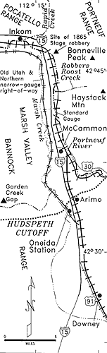
Map
of Marsh Valley.
|
||
| |
||
|
Map
of Marsh Valley.
|
Geography
and History of Drainage
Marsh
Valley, bordered on the east by the Portneuf Range and on the west by the Bannock
Range, is the primary access to the Snake River Plain from the south. As the
area was, after 1867, part of the Fort Hall Indian Reservation, legitimate settlement
of the southern part was delayed until after 1889 when the land south of McCammon
was excised from the reservation. Euro-American settlement of northern Marsh
Valley began with the Land Run of 1902.
The Portneuf Range contains east-dipping Lower Paleozoic and Late Proterozoic rocks and the Bannock Range contains the same sequence, repeated across a normal fault that bounds the east side of Marsh Valley. The Basalt of Portneuf Valley is at the surface at the north end of Marsh Valley, having been erupted from the Bancroft area about 600,000 years ago.
The north end of Marsh Valley today contains an example of "inverted topography" with the lava flows filling the middle of the valley and the rivers confined to the sides. The Portneuf River is on the east and Marsh Creek, the main path of the Lake Bonneville Flood, is on the west. At the time of eruption of the lava flow, the center of the valley was lowest, and thus the term "inverted topography."
Geophysical surveys indicate that there is as much as 10,000 feet of valley fill underneath Downey, and that over the last few million years, drainage in Marsh Valley was primarily to the south, perhaps into a lake basin which periodically had an outlet to the Bonneville Basin. The prominent pediment surfaces seen below Scout Mountain and Mount Bonneville were established during this time of southward drainage and are graded to a base level several hundred feet above the present valley floor.
After establishment of the throughgoing drainage of the ancestral Bear River, the base level fell and the pediments were incised. Garden Creek which had been flowing east on deposits of gravel and sand began cutting down and encountered the bedrock ridge at Garden Creek Gap. It continued downcutting, resulting in the superposed canyon seen today.
|
Osborne Russell's thoughts on leaving southeastern Idaho for the Willamette Valley of Oregon in 1842.
|