Response Functions
- How Can Response Functions be Used?
Response functions describe
the response of specific river reaches to ground water pumping or recharge at
specific locations for specific times. In physical situations where response
functions are applicable (see section on assumptions),
response functions may have several uses.
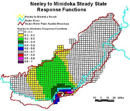
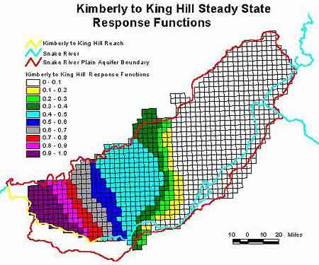
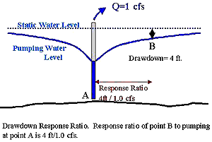 One
of the most basic uses of response functions may be to obtain and convey a better
understanding of the way in which surface water systems interact with ground
water systems. Graphs showing how response (stream depletion) changes
with time are one way of gaining an understanding of the attenuation of pumping
effects on surface water resources. Superimposing these graphs on a map
provides additional information on how impacts change depending on the location
of pumping (see figure right). Contouring response ratios (response functions
at a single point in time) for an entire aquifer can portray how different pumping
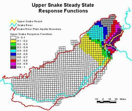
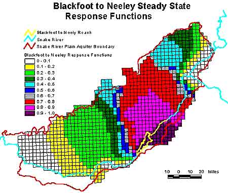
locations impact a given river reach. In the Snake River Plain aquifer,
contours of steady state response functions (response after many years of continuous
pumping) can provide guidance to water managers as to the degree that pumping
in any area impacts different reaches of the Snake River: Upper
Snake reaches, Blackfoot
to Neeley reach, Neeley
to Minidoka reach, and Kimberly
to King Hill reach.
One
of the most basic uses of response functions may be to obtain and convey a better
understanding of the way in which surface water systems interact with ground
water systems. Graphs showing how response (stream depletion) changes
with time are one way of gaining an understanding of the attenuation of pumping
effects on surface water resources. Superimposing these graphs on a map
provides additional information on how impacts change depending on the location
of pumping (see figure right). Contouring response ratios (response functions
at a single point in time) for an entire aquifer can portray how different pumping
locations impact a given river reach. In the Snake River Plain aquifer,
contours of steady state response functions (response after many years of continuous
pumping) can provide guidance to water managers as to the degree that pumping
in any area impacts different reaches of the Snake River: Upper
Snake reaches, Blackfoot
to Neeley reach, Neeley
to Minidoka reach, and Kimberly
to King Hill reach.
In many states, ground
water and surface water supplies are being conjunctively managed (see Water
Rights and Conjunctive Management page). This integrated management
philosophy may result in ground water users being held partially responsible
for surface water shortages. If this is the case, then the quantities
that individuals or groups of ground water users are accountable for must be
determined. This determination is an essential step in development of
mitigation plans. Mitigation in the form of managed recharge will be designed
to offset injury resulting from pumping. Just as pumping impacts may be
readily determined from response functions, the counter-effect of recharge may
be assessed. Response functions may be incorporated into spreadsheet water
accounting programs to determine debits, credits, and balances associated with
ground water pumping and recharge.
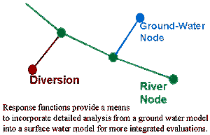 In
a simple analytical expression, or a table of numbers, response functions can
describe the response of a surface water body to ground water pumping or recharge
at a selected location. Subdividing an aquifer into a series of zones allows
representation of cause and effect relationships by a simple series of independent
equations or tables. These simplified relationships can then be incorporated
into regional surface water or multi-disciplinary models that represent the
aquifer as one component of a larger system (see figure below). This allows
the inclusion of ground water systems into more holistic ecosystem models.
In
a simple analytical expression, or a table of numbers, response functions can
describe the response of a surface water body to ground water pumping or recharge
at a selected location. Subdividing an aquifer into a series of zones allows
representation of cause and effect relationships by a simple series of independent
equations or tables. These simplified relationships can then be incorporated
into regional surface water or multi-disciplinary models that represent the
aquifer as one component of a larger system (see figure below). This allows
the inclusion of ground water systems into more holistic ecosystem models.
The additive nature of
response functions also makes them applicable to optimization techniques.
Optimization methods may be used to identify schemes to accomplish goals such
as minimizing pumping cost or drawdown at specific locations. Development
of response functions is a necessary part of optimization in ground water systems.
Information supplied by Idaho
Water Resource Research Institute, University of Idaho December 1998
Authors: Dr. Gary Johnson, Donna Cosgrove, and Mark Lovell.
Graphics: Sherry Laney and Mark Lovell of Idaho Water Resources Research Institute.
All State of Idaho images and graphics created with GIS files obtained through
Idaho Department of Water Resources Public Domain GIS unless otherwise noted.
Source
Information