Geologic Units |
|
| Quaternary alluvial deposits | |
| Quaternary surficial cover, fluveolian cover on Snake River Plain, alluvial fans (Snake River Group) | |
| Quaternary windblown deposits, dunes, loess | |
| Lake Bonneville deposits | |
| Pliocene and Upper Miocene stream and lake deposits (Salt Lake Formation, Starlight Formation, Idaho Group) | |
| Pliocene and Upper Miocene felsic volcanic rocks, rhyolite flows, tuffs, ignimbrites (includes Moonstone rhyolite) | |
| Pleistocene and Pliocene basalt lava and associated tuff | |
| Oligocene volcanics (Potlatch volcanics and Salmon Falls Creek volcanics) | |
| Upper Paleozoic sedimentary rocks | |
| Permian and Pennsylvanian sedimentary rocks | |
| Pennsylvanian sedimentary rocks | |
| Mississippian sedimentary rocks | |
| Silurian sedimentary rocks | |
| Ordovician and Cambrian sedimentary rocks | |
| Cambrian to Neoproterozoic Brigham Group | |
| Neoproterozoic Pocatello Formation |
| Map Key | |
| Geologic units with unit designation. | |
| Normal Fault: certain; dashed where approximately located; dotted where concealed. | |
| Thrust Fault: certain; dashed where approximately located; dotted where concealed. | |
| Detachment Fault: certain; dashed where approximately located; dotted where concealed. | |
| Interstate Route. | |
| U.S. Route. | |
| State Route. | |
| Location of Rockwalk rock from the county. | |
| Cities. | |
| Feature location. |
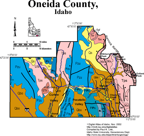
Oneida County
Oneida County spans the Utah border west of Interstate highway 15, south of Pocatello. Malad City is the county seat and only town of any size. The county is within the Basin and Range province with north-trending normal faults bounding the east sides of the ranges. The active Wasatch fault extends north of Malad Valley and then bends west to west of Elkhorn Peak.
The Bannock Range contains Neoproterozoic through Ordovician strata which are cut by slow-angle normal faults associated with the Bannock Detachment fault, which formed around 10 Ma. The ranges west of Malad Valley contain mainly upper Paleozoic rocks. The Manning Canyon thrust fault is exposed in a small canyon west of Malad, in the Blue Spring Hills.
Lake Bonneville reached into Malad, Curlew, Pocatello, and Juniper Valleys, along the Idaho-Utah border.
See geology and regional text in Rocks, Rails and Trails.
P.K. Link, 10/02
Additional Reading
Rocks Rails and Trails: pages
Introduction to the Geology of South & East Idaho
Introduction to Geologic Diagrams
Geologic cross sections
Relations between Geology, Topography and Drainage Systems in Idaho
Drainage and mountain range map for eastern Idaho
Table of Geologic Events in Southern Idaho
Drainage Systems, Rails and Trails
Geologic Provinces along the Oregon Trail
Rocks of the Eastern Idaho Mountains
The Thrust Belt of Southeastern Idaho
Views of Thrust Faults
Basin and Range Faulting
Lake Bonneville and its Flood
Disposal of Wastes at the Idaho National Engineering & Environmental Laboratory
References on Idaho Geology
Section 3, History of Eastern Idaho
Section 3, Chapter 8 -"Famous Potatoes" Agriculture & Irrigation
Section 4, Chapter 15 -Malad Valley & Country to the West
Click here to see a correlation of geologic units, and the associated time scale.
Click here for a printable version of this map.
|
Click on the button below to search the IdahoGeologic
Survey's index of Geologic Maps
|
 |