Geologic Units |
|
| Quaternary alluvial deposits | |
| Quaternary surficial cover, fluveolian cover on Snake River Plain, alluvial fans (Snake River Group) | |
| Quaternary windblown deposits, dunes, loess | |
| Bonneville Flood gravels | |
| Recent basalt lava | |
| Pleistocene basalt lava | |
| Pleistocene and Pliocene basalt lava and associated tuff | |
| Pliocene and Upper Miocene stream and lake deposits (Salt Lake Formation, Starlight Formation, Idaho Group) | |
| Oligocene volcanics (Potlatch volcanics and Salmon Falls Creek volcanics) | |
| Upper Paleozoic sedimentary rocks | |
| Permian sedimentary rocks | |
| Permian and Pennsylvanian sedimentary rocks | |
| Pennsylvanian sedimentary rocks | |
| Mississippian sedimentary rocks | |
| Silurian sedimentary rocks | |
| Ordovician sedimentary rocks | |
| Cambrian sedimentary rocks | |
| Cambrian to Neoproterozoic Brigham Group | |
| Neoproterozoic Pocatello Formation |
| Map Key | |
| Geologic units with unit designation. | |
| Normal Fault: certain; dashed where approximately located; dotted where concealed. | |
| Thrust Fault: certain; dashed where approximately located; dotted where concealed. | |
| Detachment Fault: certain; dashed where approximately located; dotted where concealed. | |
| Interstate Route. | |
| U.S. Route. | |
| State Route. | |
| Location of Rockwalk rock from the county. | |
| Cities. | |
| Feature location. |
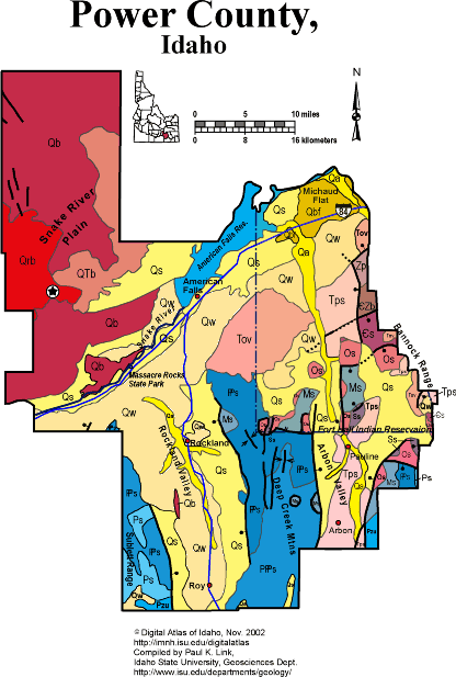
Power County
Power County straddles the Snake River west of Pocatello. It has fresh basalt lava of the Great Rift and Kings Bowl in its northwestern corner. The central part of the county is agricultural land irrigated by the Snake River. Here 70,000 years ago the ancestral American Falls lake existed. South of the Snake River, farming occurs in Rockland and Arbon Valleys, south of the Snake River.
Massacre Rocks along the Snake River is a Miocene basalt eruptive center. The Oregon Trail runs through it. See description in Rocks, Rails and Trails.
The Bannock, Deep Creek and Sublett Ranges, south of the Snake River, contain Paleozoic sedimentary rocks in the hanging wall of the Putnam thrust fault.
See geology description in Rocks, Rails and Trails.
P.K. Link, 10/02
Additional Reading
Rocks Rails and Trails: pages
Introduction to the Geology of South & East Idaho
Introduction to Geologic Diagrams
Geologic cross sections
Relations between Geology, Topography and Drainage Systems in Idaho
Drainage and mountain range map for eastern Idaho
Table of Geologic Events in Southern Idaho
The Snake River Plain-Yellowstone Hot Spot and its Effect on Drainage Patterns
Challis Volcanic Group & Intrusive Rocks
Lake Bonneville and its Flood
Disposal of Wastes at the Idaho National Engineering & Environmental Laboratory
References on Idaho Geology
Section 3, History of Eastern Idaho
Section 3, Chapter 8 -"Famous Potatoes" Agriculture & Irrigation
Section 6, Chapter 21 - American Falls Area
Massacre Rocks
Section 7, Chapter 22 - Silent City of Rocks & Burley Area
Click here to see a correlation of geologic units, and the associated time scale.
Click here for a printable version of this msp.
|
Click on the button below to search the IdahoGeologic
Survey's index of Geologic Maps
|
 |