Geologic Units |
|
| Quaternary alluvial deposits | |
| Pleistocene silicic volcanic rocks (Yellowstone Group) | |
| Pleistocene basalt lava | |
| Pleistocene and Pliocene stream and lake deposits | |
| Pliocene and Upper Miocene felsic volcanic rocks, rhyolite flows, tuffs, ignimbrites (includes Moonstone rhyolite) | |
| Cretaceous sedimentary rocks | |
| Jurassic sedimentary rocks. | |
| Triassic sedimentary rocks | |
| Permian and Pennsylvanian sedimentary rocks | |
| Mississippian sedimentary rocks | |
| Devonian sedimentary rocks | |
| Ordovician and Cambrian sedimentary rocks |
| Map Key | |
| Geologic units with unit designation. | |
| Normal Fault: certain; dashed where approximately located; dotted where concealed. | |
| Thrust Fault: certain; dashed where approximately located; dotted where concealed. | |
| Detachment Fault: certain; dashed where approximately located; dotted where concealed. | |
| Interstate Route. | |
| U.S. Route. | |
| State Route. | |
| Location of Rockwalk rock from the county. | |
| Cities. | |
| Feature location. |
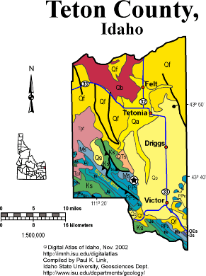
Teton County
Much of Teton County occupies Pierre's Hole, or the Teton Valley, which lies west of the Teton Mountains and northeast of the Big Hole Mountains. The bulk of the county is underlain by Quaternary sediment, and is thus eminently suited for agriculture, which has dominated the economy until the last 20 years when vacation homes and tourism have become increasingly important.
The Big Hole Mountains, in the southwestern part of the county, contain folded and thrust faulted sedimentary rocks, which in Teton County are mostly of Mesozoic age. Coal is found in Cretaceous strata in the Horseshoe basin west of Driggs. In the 1980s wells were drilled for oil in these mountains.
Teton Pass, at the southeast corner of the county, exposes very complex geology where the north dipping Cache Creek reverse fault, that formed in the Paleocene Laramide orogeny, impinged on rocks carried northeastward by the south-dipping Jackson thrust fault of the Idaho-Wyoming thrust belt
Miocene rhyolite of the Heise and Yellowstone volcanic fields occupies the north end of the Big Hole Mountains, and is incised deeply by the Teton River as it tracks westward toward the Snake.
The eastern border of the county, and the state of Idaho, is in the agricultural area west of the Teton Mountains. The Tetons rise dramatically on dip slopes formed from west-dipping Paleozoic carbonate strata. At the top of the Targhee ski area, the rocks are Mississippian. On Table Mountain they are the Cambrian-Archean unconformity, and on the Grand Teton the rocks are Archean gneiss.
P.K. Link, 9/02
Additional Reading
Rocks Rails and Trails: pages
Introduction to the Geology of South & East Idaho
Introduction to Geologic Diagrams
Geologic cross sections
Relations between Geology, Topography and Drainage Systems in Idaho
Drainage and mountain range map for eastern Idaho
Table of Geologic Events in Southern Idaho
The Thrust Belt of Southeastern Idaho
Views of Thrust Faults
Challis Volcanic Group & Intrusive Rocks
References on Idaho Geology
Section 3, History of Eastern Idaho
Section 3, Chapter 8 -"Famous Potatoes" Agriculture & Irrigation
The Teton Dam Disaster, June 5, 1976
Click here to see a correlation of geologic units, and the associated time scale.
Click here for a printable version of this map.
|
Click on the button below to search the IdahoGeologic
Survey's index of Geologic Maps
|
 |