Geologic Units |
|
| Quaternary surficial cover, fluveolian cover on Snake River Plain, alluvial fans (Snake River Group) | |
| Quaternary alluvial deposits | |
| Pliocene and Upper Miocene stream and lake deposits (Salt Lake Formation, Starlight Formation, Idaho Group) | |
| Eocene sedimentary rocks | |
| Triassic sedimentary rocks | |
| Jurassic sedimentary rocks. | |
| Permian and Pennsylvanian sedimentary rocks | |
| Ordovician sedimentary rocks | |
| Silurian sedimentary rocks | |
| Devonian sedimentary rocks |
| Map Key | |
| Geologic units with unit designation. | |
| Normal Fault: certain; dashed where approximately located; dotted where concealed. | |
| Thrust Fault: certain; dashed where approximately located; dotted where concealed. | |
| Detachment Fault: certain; dashed where approximately located; dotted where concealed. | |
| Interstate Route. | |
| U.S. Route. | |
| State Route. | |
| Location of Rockwalk rock from the county. | |
| Cities. | |
| Feature location. |
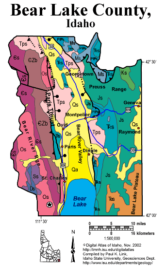
Bear Lake County
In Idaho's southeast corner, Bear Lake County is with both the Idaho-Wyoming thrust belt and the Basin and Range province. Drilling for oil was big news here in the late 1970s and 1980s, and it will happen again. Rich phosphate ore of the Phosphoria Formation allowed development of mines in Georgetown, Paris and Montpelier through the 20th century.
For more detail on the geology of Bear Lake County see the text from Rocks, Rails and Trails Also see the Fortsch and Link field trip guide in Geologic Guidebook to eastern Idaho.
P.K. Link 10/02
Additional Reading
Rocks Rails and Trails: pages:
Introduction to the
Geology of South & East Idaho
Introduction to Geologic Diagrams
Geologic cross sections
Relations between Geology, Topography
and Drainage Systems in Idaho
Drainage and mountain range map
for eastern Idaho
Table of Geologic Events in
Southern Idaho
Drainage Systems, Rails and
Trails
Geologic Provinces along the
Oregon Trail
Rocks of the Eastern Idaho Mountains
Southeast Idaho Phosphate Mining
The Thrust Belt of Southeastern
Idaho
Views of Thrust Faults
Basin and Range Faulting
References on Idaho Geology
Section 3, History of Eastern
Idaho
Section 3, Chapter 8 -"Famous
Potatoes" Agriculture & Irrigation
Section 4, Chapter 9 -The
Bear Lake Valley
Montpelier
Geology of the Soda Springs
Area
Click here to see a correlation of geologic units, and the associated time scale.
Click here for a printable version of this map.
|
Click on the button below to search the IdahoGeologic
Survey's index of Geologic Maps
|
 |