Geologic Units |
|
| Quaternary alluvial deposits | |
| Quaternary surficial cover, fluveolian cover on Snake River Plain, alluvial fans (Snake River Group) | |
| Quaternary windblown deposits, dunes, loess | |
| Pleistocene silicic volcanic rocks (Yellowstone Group) | |
| Recent basalt lava | |
| Pleistocene basalt lava | |
| Pliocene and Upper Miocene stream and lake deposits (Salt Lake Formation, Starlight Formation, Idaho Group) | |
| Pliocene and Upper Miocene felsic volcanic rocks, rhyolite flows, tuffs, ignimbrites (includes Moonstone rhyolite) | |
| Pleistocene and Pliocene basalt lava and associated tuff | |
| Cretaceous sedimentary rocks | |
| Jurassic sedimentary rocks. | |
| Triassic sedimentary rocks | |
| Permian and Pennsylvanian sedimentary rocks | |
| Devonian sedimentary rocks | |
| Ordovician and Cambrian sedimentary rocks |
| Map Key | |
| Geologic units with unit designation. | |
| Normal Fault: certain; dashed where approximately located; dotted where concealed. | |
| Thrust Fault: certain; dashed where approximately located; dotted where concealed. | |
| Detachment Fault: certain; dashed where approximately located; dotted where concealed. | |
| Interstate Route. | |
| U.S. Route. | |
| State Route. | |
| Location of Rockwalk rock from the county. | |
| Cities. | |
| Feature location. |
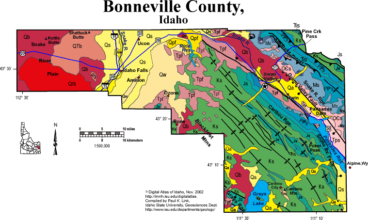
Bonneville County
Bonneville County covers a huge area in eastern Idaho, spanning from the Snake River Plain on the west to the Wyoming border on the east. The horseshoe path of the Snake River is mainly within the county as the river exits the Grand Canyon of the Snake at Alpine Wyoming, and flows north through Palisades Dam and Swan Valley, all within the Miocene to Recent Grand Valley graben.
The populated irrigated areas along the Snake River near Idaho Falls hold almost all of Bonneville County's residents, but the nearly empty back county contains beautiful forested mountains on the east and wide open sagebrush desert on the west.
The eastern part of the county, including the Caribou and Snake River ranges, is in the Idaho-Wyoming thrust belt, with the Absaroka thrust cropping out about half way up highway 31 toward Pine Creek Pass. This regional structure puts Paleozoic on Mesozoic rocks. Numerous folds are found in Mesozoic rocks in the Caribou Range, in the hanging-wall of the Absaroka thrust fault, and on the west side of the Grand Valley graben.
Grand Valley is a Miocene to Recent feature. The main, Grand Valley fault is on the east side. A subsidiary fault, the Snake River fault, is on the west side, west of Swan Valley.
In the southwest of the county is the Grays Lake lava field, filled with Pleistocene basalts of the Willow Creek volcanic field, and now covered with the shallow waters of Grays Lake, a national wildlife refuge.
For more information see the Idaho-Wyoming thrust fault text from Rocks, Rails and Trails.
P.K. Link, 10/02
Additional Reading
Rocks Rails and Trails: pages
Introduction to the Geology of South & East Idaho
Introduction to Geologic Diagrams
Geologic cross sections
Relations between Geology, Topography and Drainage Systems in Idaho
Drainage and mountain range map for eastern Idaho
Table of Geologic Events in Southern Idaho
The Snake River Plain-Yellowstone Hot Spot and its Effect on Drainage Patterns
Drainage Systems, Rails and Trails
Geologic Provinces along the Oregon Trail
Rocks of the Eastern Idaho Mountains
The Thrust Belt of Southeastern Idaho
Views of Thrust Faults
Basin and Range Faulting
Challis Volcanic Group & Intrusive Rocks
Disposal of Wastes at the Idaho National Engineering & Environmental Laboratory
References on Idaho Geology
Section 3, History of Eastern Idaho
Section 3, Chapter 8 -"Famous Potatoes" Agriculture & Irrigation
The Teton Dam Disaster, June 5, 1976
Geology of the Soda Springs Area
Section 4, Chapter 11 -Caribou Mountain Area
Section 4, Chapter 12 -Gem Valley & Chesterfield
Section 6, Chapter 20 - Root Hog, Big Butte & Craters of the Moon
Click here to see a correlation of geologic units, and the associated time scale.
Click here for a printable version of this map.
|
Click on the button below to search the IdahoGeologic
Survey's index of Geologic Maps
|
 |