 |
|
Click on the map above for a larger version
|
Geologic Units |
|
| Quaternary alluvial deposits | |
| Quaternary surficial cover, fluveolian cover on Snake River Plain, alluvial fans (Snake River Group) | |
| Quaternary windblown deposits, dunes, loess | |
| Eocene Challis Volcanic Group, volcanics and volcaniclastics | |
| Recent basalt lava | |
| Pleistocene and Pliocene basalt lava and associated tuff | |
| Pliocene and Upper Miocene stream and lake deposits (Salt Lake Formation, Starlight Formation, Idaho Group) | |
| Pliocene and Upper Miocene felsic volcanic rocks, rhyolite flows, tuffs, ignimbrites (includes Moonstone rhyolite) | |
| Pennsylvanian sedimentary rocks | |
| Silurian and Ordovician sedimentary rocks | |
| Ordovician sedimentary rocks | |
| Devonian sedimentary rocks | |
| Paleozoic/Neoproterozoic metasedimentary rocks (includes formation of Leaton Gulch) | |
| Neoproterozoic sedimentary rocks | |
| Pleistocene silicic volcanic rocks (Yellowstone Group) | |
| Pleistocene basalt lava | |
| Pleistocene and Pliocene basalt lava and associated tuff | |
| Mississippian sedimentary rocks |
| Map Key | |
| Geologic units with unit designation. | |
| Normal Fault: certain; dashed where approximately located; dotted where concealed. | |
| Thrust Fault: certain; dashed where approximately located; dotted where concealed. | |
| Detachment Fault: certain; dashed where approximately located; dotted where concealed. | |
| Interstate Route. | |
| U.S. Route. | |
| State Route. | |
| Location of Rockwalk rock from the county. | |
| Cities. | |
| Feature location. |
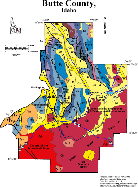
Butte County
Butte County, though sparsely populated, contains some very interesting geology.
The Snake River Plain, with Craters of the Moon to the south and the INEEL to the northeast, underlies the southern portion of Butte County. Irrigated farming supports the economy near Arco and Howe, where alluvial sediment lies above Quaternary basalt lava. The lava supports only a sagebrush habitat, much of which is grazed off the INEEL boundary. The composite Quaternary rhyolite dome of Big Southern Butte makes a landmark visible for hundreds of miles. The Butte consists of thick pasty rhyolite magma that was emplaced upward, like a wart through a skin of Quaternary and Recent basalt.
The Big Lost River flows northeast across basalt lava through the county, and ends in the Lost River Sinks east of Howe. Extensive irrigated agriculture is supported in this area.
The northeastern part of Butte County is underlain by the Lemhi Range, composed of Mesoproterozoic Belt Supergroup overlain by Paleozoic strata, mainly carbonates. The rocks were folded and thrust faulted in the Cretaceous Sevier orogeny. The western boundary of the Lemhi Range is the active Lemhi Fault. To the west is the Little Lost River Valley, which provides access via Summit Creek to the high Lemhis. Just northeast of Howe near South Creek is a block of Paleozoic rocks that slid southwest from the Lemhi Range into the Little Lost River Valley.
West of the Little Lost River is the Lost River Range, underlain by the same strata as the Lemhi Range, and deformed in similar manner. The active Lost River fault zone, which last moved in 1983, bounds the east side of the Lost River Valley east of Arco, Darlington and Moore. The Arco Hills, underlain by folded Paleozoic carbonate rocks, lie east of the Arco Pass half graben, an Eocene structure.
Eocene Challis volcanic rocks covered north-trending half grabens in the Lost River Range, and are overlain by Oligocene and Miocene tuffs, conglomerates and lake beds.
West of the Lost River Valley is Appendicitis Hill of the southern Pioneer Mountains. Much of the western corner of the county is underlain by Eocene Challis volcanic rocks, which overlie folded Mississippian turbidites of the Copper Basin Group.
Craters of the Moon National Monument contains Quaternary and Recent basalt eruptive complex. The vents and fissures follow Basin and Range fault zones, which strike northwest across the area. The last eruption occurred only 2,000 years ago.
See several sections in Rocks, Rails and Trails, including Snake River Plain and Borah Peak fault, plus the Link and Janecke geologic road log in Guidebook to the Geology of Eastern Idaho.
P.K. Link, 10/02
Additional Reading
Rocks Rails and Trails: pages
Introduction to the Geology of South & East Idaho
Introduction to Geologic Diagrams
Geologic cross sections
Relations between Geology, Topography and Drainage Systems in Idaho
Drainage and mountain range map for eastern Idaho
Table of Geologic Events in Southern Idaho
The Snake River Plain-Yellowstone Hot Spot and its Effect on Drainage Patterns
Drainage Systems, Rails and Trails
Geologic Provinces along the Oregon Trail
Rocks of the Eastern Idaho Mountains
Rocks of Central Idaho
Pictures -Idaho Mountains
Basin and Range Faulting
The Borah Peak Area & the October, 1983 Earthquake
Challis Volcanic Group & Intrusive Rocks
Glaciation in the Mountains of South-Central Idaho
Disposal of Wastes at the Idaho National Engineering & Environmental Laboratory
References on Idaho Geology
Section 3, History of Eastern Idaho
Section 3, Chapter 8 -"Famous Potatoes" Agriculture & Irrigation
Section 6, Chapter 20 - Root Hog, Big Butte & Craters of the Moon
Click here to see a correlation of geologic units, and the associated time scale.
Click here for a printable version of this map.
|
Click on the button below to search the IdahoGeologic
Survey's index of Geologic Maps
|
 |