|
| Click on the image above for a larger view |
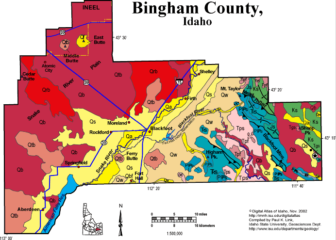
Geologic Units |
|
| Quaternary alluvial deposits | |
| Quaternary surficial cover, fluveolian cover on Snake River Plain, alluvial fans (Snake River Group) | |
| Quaternary windblown deposits, dunes, loess (omitted in Northern Idaho) | |
| Pleistocene silicic volcanic rocks (Yellowstone Group) | |
| Recent basalt lava | |
| Pleistocene basalt lava | |
| Pleistocene and Pliocene basalt lava and associated tuff | |
| Pliocene and Upper Miocene felsic volcanic rocks, rhyolite flows, tuffs, ignimbrites (includes Moonstone rhyolite) | |
| Triassic sedimentary rocks | |
| Pliocene and Upper Miocene stream and lake deposits (Salt Lake Formation, Starlight Formation, Idaho Group) | |
| Cretaceous sedimentary rocks | |
| Eocene granite, pink granite, syenite, rhyolite dikes, and rhyolitic shallow intrusive | |
| Permian and Pennsylvanian sedimentary rocks | |
| Jurassic sedimentary rocks. | |
| Mississippian sedimentary rocks |
| Map Key | |
| Geologic units with unit designation. | |
| Normal Fault: certain; dashed where approximately located; dotted where concealed. | |
| Thrust Fault: certain; dashed where approximately located; dotted where concealed. | |
| Detachment Fault: certain; dashed where approximately located; dotted where concealed. | |
| Interstate Route. | |
| U.S. Route. | |
| State Route. | |
| Location of Rockwalk rock from the county. | |
| Cities. | |
| Feature location. |
Bingham County
Bingham County covers a vast area, much of it on the Snake River Plain and the foothills of the Blackfoot Mountains on the east.
Irrigated farms on both sides of the Snake River make Bingham County and Blackfoot the center of Idaho potato production. Beyond the irrigated farms to the northwest is the sagebrush desert of the Snake River Plain and the area around Atomic City, where dryland wheat farming was attempted in the 1920s.
In the northwestern panhandle of the county is a portion of the Idaho National Engineering and Environmental Laboratory, and two of the three buttes, landmarks on the Snake River Plain. Both Middle Butte and East Butte are rhyolite domes, but Middle Butte has not breached its Pleistocene basalt cap.
In the southeast of the county, in the hanging wall of the Meade thrust fault, near Mt. Taylor, is phosphate mining country, including the now-closed Gay Mine, on the Fort Hall Indian Reservation.
See Root Hog, Blackfoot, and regional geology text from Rocks Rails and Trails. Also see Hughes et al. and McCurry et al. field trip in Guidebook to the Geology of Eastern Idaho.
P.K. Link, 10/02
Additional Reading
Rocks Rails and Trails: page
Introduction to the Geology of South & East Idaho
Introduction to Geologic Diagrams
Geologic cross sections
Relations between Geology, Topography
and Drainage Systems in Idaho
Drainage and mountain range map
for eastern Idaho
Table of Geologic Events in
Southern Idaho
The Snake River Plain-Yellowstone
Hot Spot and its Effect on Drainage Patterns
Drainage Systems, Rails and
Trails
Geologic Provinces along the
Oregon Trail
Rocks of the Eastern Idaho Mountains
Southeast Idaho Phosphate Mining
The Thrust Belt of Southeastern
Idaho
Views of Thrust Faults
Challis Volcanic Group & Intrusive
Rocks
Disposal of Wastes at the Idaho
National Engineering & Environmental Laboratory
References on Idaho Geology
Section 3, History of Eastern
Idaho
Section 3, Chapter 8 -"Famous
Potatoes" Agriculture & Irrigation
The Teton Dam Disaster,
June 5, 1976
Section 4, Chapter 12
-Gem Valley & Chesterfield
Blackfoot
Section 6, Chapter 20
- Root Hog, Big Butte & Craters of the Moon and Section 6, Chapter 21
- American Falls Area
Click here to see a correlation of geologic units, and the associated time scale.
Click here for a printable version of this map.
|
Click on the button below to search the IdahoGeologic
Survey's index of Geologic Maps
|
 |